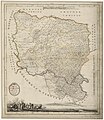
File:Map of Banat of Temeswar by Castulus Riedl.jpg
Appearance

Size of this preview: 519 × 599 pixels. Other resolutions: 208 × 240 pixels | 415 × 480 pixels | 665 × 768 pixels | 886 × 1,024 pixels | 1,773 × 2,048 pixels | 8,550 × 9,876 pixels.
Original file (8,550 × 9,876 pixels, file size: 14.2 MB, MIME type: image/jpeg)
File history
Click on a date/time to view the file as it appeared at that time.
| Date/Time | Thumbnail | Dimensions | User | Comment | |
|---|---|---|---|---|---|
| current | 09:20, 12 June 2023 |  | 8,550 × 9,876 (14.2 MB) | Trauenbaum | Uploaded a work by Castulus Riedl, Johann Michael Mettenleitter, Joseph Georg Winter from Karte von dem Banat Temeswar und einigen Districten auf servischer Seite – Geographii. aufgenommen von Castulus Riedl K: Palz Bayr: Ingen: Capit ; Gestochen von M. Mettenleitter in der Direct. des J. G. Wintter in München 1789. Bibliothèque nationale de France, GED-420 with UploadWizard |
File usage
No pages on the English Wikipedia use this file (pages on other projects are not listed).


