
File:Map of Italy in 1300 (simplified)-NL.svg

Size of this PNG preview of this SVG file: 501 × 600 pixels. Other resolutions: 200 × 240 pixels | 401 × 480 pixels | 641 × 768 pixels | 855 × 1,024 pixels | 1,711 × 2,048 pixels | 1,624 × 1,944 pixels.
Original file (SVG file, nominally 1,624 × 1,944 pixels, file size: 684 KB)
| This is a file from the Wikimedia Commons. Information from its description page there is shown below. Commons is a freely licensed media file repository. You can help. |
-NL.svg)
Summary
| Description |
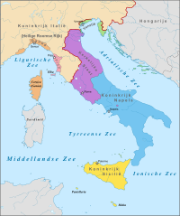
Nederlands: Kaart van Italië in 1300. De meeste stadstaten in het noorden zijn niet weergegeven. |
| Date | |
| Source | Own work, based on File:Italy map-blank.svg by Eric Gaba (Sting - fr:Sting). |
| Author | Sir Iain |
Licensing
I, the copyright holder of this work, hereby publish it under the following license:
This file is licensed under the Creative Commons Attribution-Share Alike 3.0 Unported license.
- You are free:
- to share – to copy, distribute and transmit the work
- to remix – to adapt the work
- Under the following conditions:
- attribution – You must give appropriate credit, provide a link to the license, and indicate if changes were made. You may do so in any reasonable manner, but not in any way that suggests the licensor endorses you or your use.
- share alike – If you remix, transform, or build upon the material, you must distribute your contributions under the same or compatible license as the original.
File history
Click on a date/time to view the file as it appeared at that time.
| Date/Time | Thumbnail | Dimensions | User | Comment | |
|---|---|---|---|---|---|
| current | 16:46, 20 July 2013 | | 1,624 × 1,944 (684 KB) | Sir Iain | Corrected spelling error |
File usage
No pages on the English Wikipedia use this file (pages on other projects are not listed).
Global file usage
The following other wikis use this file:
- Usage on ar.wikipedia.org
- Usage on az.wikipedia.org
- Usage on he.wikipedia.org
- Usage on id.wikibooks.org
- Usage on ms.wikipedia.org
- Usage on nl.wikipedia.org
- Usage on ru.wikipedia.org
- Usage on sr.wikipedia.org
- Usage on uk.wikipedia.org
-NL.svg)