
File:Map of JAT367.png

Size of this preview: 640 × 600 pixels. Other resolutions: 256 × 240 pixels | 819 × 768 pixels | 1,092 × 1,024 pixels | 1,600 × 1,500 pixels.
Original file (1,600 × 1,500 pixels, file size: 374 KB, MIME type: image/png)
| This is a file from the Wikimedia Commons. Information from its description page there is shown below. Commons is a freely licensed media file repository. You can help. |
Summary
| Description |
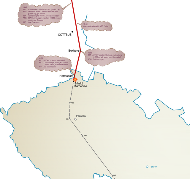
English: Map of flight JAT367 - based on official Final Report |
| Date | |
| Source | Own work |
| Author | Karel x |
Licensing
| I, the copyright holder of this work, release this work into the public domain. This applies worldwide. In some countries this may not be legally possible; if so: I grant anyone the right to use this work for any purpose, without any conditions, unless such conditions are required by law. |
File history
Click on a date/time to view the file as it appeared at that time.
| Date/Time | Thumbnail | Dimensions | User | Comment | |
|---|---|---|---|---|---|
| current | 16:51, 8 April 2010 | | 1,600 × 1,500 (374 KB) | Karel x | Fixing altitude to 10.050 m (FL330) |
| 10:27, 20 July 2009 |  | 1,600 × 1,500 (365 KB) | Karel x | {{Information |Description={{en|1=Map of flight JAT367}} |Source=Own work by uploader |Author=Karel x |Date=2009-07-20 |Permission= |other_versions= }} Category:Air disasters in 1972 [[Category:Aviation accidents in the Czech Republi |
File usage
The following pages on the English Wikipedia use this file (pages on other projects are not listed):
Global file usage
The following other wikis use this file:
- Usage on cs.wikipedia.org
- Usage on de.wikipedia.org
- Usage on fi.wikipedia.org
- Usage on he.wikipedia.org
- Usage on it.wikipedia.org
- Usage on pt.wikipedia.org
- Usage on sk.wikipedia.org
- Usage on zh.wikipedia.org