
File:Map of Jubaland.png

Size of this preview: 295 × 598 pixels. Other resolutions: 118 × 240 pixels | 236 × 480 pixels | 378 × 768 pixels | 505 × 1,024 pixels | 1,328 × 2,694 pixels.
Original file (1,328 × 2,694 pixels, file size: 7.36 MB, MIME type: image/png)
| This is a file from the Wikimedia Commons. Information from its description page there is shown below. Commons is a freely licensed media file repository. You can help. |
Summary
| Description |
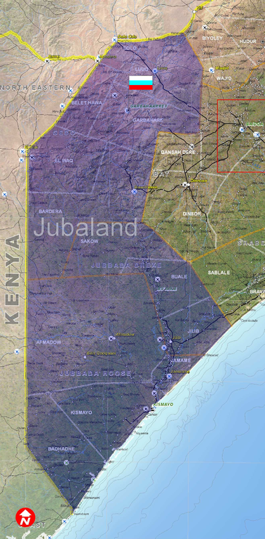
English: Jubaland map, is a detailed map of Jubaland territory including the three provinces of Jubaland(Jubbada Hoose, Jubbada Dhexe & Gedo) and the many districts. the capital of the autonomous state of Jubaland is Garbohaarey, the commercial capital is Kismaayo and the most populous city is Beledxaawo. |
| Date | |
| Source | Own work |
| Author | Ibra101 |
Jubaland is an autonomous regional administration within the Democratic Republic state of Somalia in the Horn of Africa(East Africa). the name of the region comes from the Jubba river that runs from Doollow in Gedo to Jubbada Hoose where it joins the indean ocean.
Licensing
I, the copyright holder of this work, hereby publish it under the following licenses:
This file is licensed under the Creative Commons Attribution-Share Alike 3.0 Unported license.
- You are free:
- to share – to copy, distribute and transmit the work
- to remix – to adapt the work
- Under the following conditions:
- attribution – You must give appropriate credit, provide a link to the license, and indicate if changes were made. You may do so in any reasonable manner, but not in any way that suggests the licensor endorses you or your use.
- share alike – If you remix, transform, or build upon the material, you must distribute your contributions under the same or compatible license as the original.

|
Permission is granted to copy, distribute and/or modify this document under the terms of the GNU Free Documentation License, Version 1.2 or any later version published by the Free Software Foundation; with no Invariant Sections, no Front-Cover Texts, and no Back-Cover Texts. A copy of the license is included in the section entitled GNU Free Documentation License. |
You may select the license of your choice.
File history
Click on a date/time to view the file as it appeared at that time.
| Date/Time | Thumbnail | Dimensions | User | Comment | |
|---|---|---|---|---|---|
| current | 15:08, 23 October 2012 | | 1,328 × 2,694 (7.36 MB) | Wolfiukas | New Flag |
| 15:04, 23 October 2012 |  | 1,328 × 2,694 (7.36 MB) | Wolfiukas | New Flag | |
| 19:16, 26 February 2011 |  | 1,328 × 2,694 (6.3 MB) | Ibra101 | {{Information |Description ={{en|1=Jubaland map, is a detailed map of Jubaland territory including the three provinces of Jubaland(Jubbada Hoose, Jubbada Dhexe & Gedo) and the many districts. the capital of the autonomous state of Jubaland is Garbohaar |
File usage
No pages on the English Wikipedia use this file (pages on other projects are not listed).
Global file usage
The following other wikis use this file:
- Usage on de.wikipedia.org
- Usage on fa.wikipedia.org
- Usage on hu.wikipedia.org
- Usage on sr.wikipedia.org