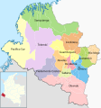
File:Mapa de Nariño (subregiones).svg
Appearance

Size of this PNG preview of this SVG file: 561 × 600 pixels. Other resolutions: 225 × 240 pixels | 449 × 480 pixels | 719 × 768 pixels | 958 × 1,024 pixels | 1,916 × 2,048 pixels | 1,353 × 1,446 pixels.
Original file (SVG file, nominally 1,353 × 1,446 pixels, file size: 714 KB)
File history
Click on a date/time to view the file as it appeared at that time.
| Date/Time | Thumbnail | Dimensions | User | Comment | |
|---|---|---|---|---|---|
| current | 06:32, 22 March 2022 |  | 1,353 × 1,446 (714 KB) | Milenioscuro | actualizo |
| 22:13, 14 July 2016 |  | 1,353 × 1,446 (514 KB) | Milenioscuro | User created page with UploadWizard |
File usage
The following page uses this file:
Global file usage
The following other wikis use this file:
- Usage on avk.wikipedia.org
- Leiva (Nariño)
- El Rosario (Nariño)
- Policarpa
- Taminango
- NariñoJuanambúUtca
- Teza:Utceem ke Nariño (Kolombia)
- Teza:NariñoDoteem
- San Pablo (Nariño)
- Belén (Nariño)
- Colón (Nariño)
- San Pedro de Cartago
- Arboleda (Nariño)
- San José de Albán
- El Tablón de Gómez
- La Cruz (Nariño)
- San Bernardo (Nariño)
- San Lorenzo (Nariño)
- La Unión (Nariño)
- Cumbitara
- NariñoTúquerresUtca
- La Llanada
- Los Andes (Nariño)
- Linares (Nariño)
- Providencia (Nariño)
- Samaniego (Nariño)
- Ancuya
- Guaitarilla
- Santacruz
- Imués
- Ospina
- Túquerres
- Mallama
- Ricaurte (Nariño)
- Sapuyes
- NariñoObandoUtca
- Funes (Nariño)
- Iles
- Contadero
- Gualmatán
- Puerres
- Córdoba (Nariño)
- Potosí (Nariño)
- Guachucal
- Aldana
- Cumbal (Nariño)
- Pupiales
- Cuaspud
- Ipiales
- El Peñol (Nariño)
- NariñoPastoUtca
View more global usage of this file.
