
File:May1803 Canada L1A.jpg

Size of this preview: 426 × 599 pixels. Other resolutions: 170 × 240 pixels | 341 × 480 pixels | 546 × 768 pixels | 728 × 1,024 pixels | 1,848 × 2,600 pixels.
Original file (1,848 × 2,600 pixels, file size: 1.75 MB, MIME type: image/jpeg)
| This is a file from the Wikimedia Commons. Information from its description page there is shown below. Commons is a freely licensed media file repository. You can help. |
Summary
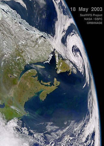
| Description | Satellite view of Canada's Atlantic provinces. |
| Date | |
| Source | http://daac.gsfc.nasa.gov/oceancolor/images/May1803_Canada_L1A.jpg. See also http://daac.gsfc.nasa.gov/oceancolor/scifocus/oceanColor/maritimes.shtml. |
| Author | SeaWIFS |
Licensing
| This image is from the Sea-viewing Wide Field-of-view Sensor (SeaWiFS) Project and more than 5 years old.
Satellite data captured by the SeaWIFS sensor are released into the public domain 5 years after capture. Data less than five years old can be re-used only for educational or scientific purposes; any commercial use of such images must be coordinated with GeoEye. [1] |
| This work has been released into the public domain by its copyright holder, GeoEye. This applies worldwide. In some countries this may not be legally possible; if so: GeoEye grants anyone the right to use this work for any purpose, without any conditions, unless such conditions are required by law.
|
File history
Click on a date/time to view the file as it appeared at that time.
| Date/Time | Thumbnail | Dimensions | User | Comment | |
|---|---|---|---|---|---|
| current | 12:34, 8 December 2007 | | 1,848 × 2,600 (1.75 MB) | Avenue | {{Information |Description=Satellite view of Maritime provinces, Canada. |Source=http://daac.gsfc.nasa.gov/oceancolor/images/May1803_Canada_L1A.jpg. See also http://daac.gsfc.nasa.gov/oceancolor/scifocus/oceanColor/maritimes.shtml. |Date=2003-05-18 |A |
File usage
No pages on the English Wikipedia use this file (pages on other projects are not listed).