
File:Medieval Oslo map.jpg

Size of this preview: 734 × 599 pixels. Other resolutions: 294 × 240 pixels | 588 × 480 pixels | 900 × 735 pixels.
Original file (900 × 735 pixels, file size: 825 KB, MIME type: image/jpeg)
| This is a file from the Wikimedia Commons. Information from its description page there is shown below. Commons is a freely licensed media file repository. You can help. |
| Description |
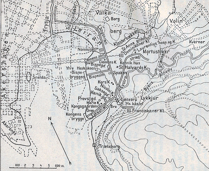
Norsk bokmål: Middelalderens Oslo tegnet inn på et kart over Kristiania fra 1917. |
||||
| Date | |||||
| Source | Topografisk-statistisk Beskrivelse over Kristiania. | ||||
| Author | Amund Helland | ||||
| Permission (Reusing this file) |
|
||||
File history
Click on a date/time to view the file as it appeared at that time.
| Date/Time | Thumbnail | Dimensions | User | Comment | |
|---|---|---|---|---|---|
| current | 19:33, 3 April 2008 | | 900 × 735 (825 KB) | Mahlum | {{Information |Description={{no|Middelalderens Oslo tegnet inn på et kart over Kristiania fra 1917.}} |Source=''Topografisk-statistisk Beskrivelse over Kristiania.'' |Date=1917 |Author=Amund Helland |Permission={{PD-old}} |other_versions= }} [[Category: |
File usage
The following pages on the English Wikipedia use this file (pages on other projects are not listed):
Global file usage
The following other wikis use this file:
- Usage on ar.wikipedia.org
- Usage on bs.wikipedia.org
- Usage on ca.wikipedia.org
- Usage on el.wikipedia.org
- Usage on fa.wikipedia.org
- Usage on nl.wikipedia.org
- Usage on no.wikipedia.org
- Usage on pt.wikipedia.org
- Usage on sl.wikipedia.org
- Usage on ur.wikipedia.org
- Usage on vi.wikipedia.org
- Usage on zh.wikipedia.org