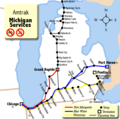
File:Michigan Services map.png
Appearance
Michigan_Services_map.png (540 × 535 pixels, file size: 51 KB, MIME type: image/png)
File history
Click on a date/time to view the file as it appeared at that time.
| Date/Time | Thumbnail | Dimensions | User | Comment | |
|---|---|---|---|---|---|
| current | 15:22, 19 April 2007 |  | 540 × 535 (51 KB) | Shadowlink1014~commonswiki | |
| 06:17, 19 April 2007 |  | 540 × 535 (51 KB) | Shadowlink1014~commonswiki | ||
| 04:35, 19 April 2007 |  | 540 × 535 (42 KB) | Shadowlink1014~commonswiki | ||
| 18:25, 18 April 2007 |  | 540 × 535 (42 KB) | Shadowlink1014~commonswiki | {{Information |Description=Map of Amtrak Michigan Services -- it consists of three lines, the ''Pere Marquette'', the ''Blue Water'', and the ''Wolverine''. The map in the background is from Map_of_USA_without_state_names.svg - which is licensed under the |
File usage
The following page uses this file:
Global file usage
The following other wikis use this file:
- Usage on en.wikinews.org
- Usage on es.wikinews.org
- Usage on fi.wikipedia.org
- Usage on he.wikinews.org
- Usage on ja.wikipedia.org
- Usage on ko.wikipedia.org
- Usage on www.wikidata.org
- Usage on zh.wikipedia.org


