
File:Moyles Court - geograph.org.uk - 620650.jpg
No higher resolution available.
Moyles_Court_-_geograph.org.uk_-_620650.jpg (640 × 427 pixels, file size: 195 KB, MIME type: image/jpeg)
| This is a file from the Wikimedia Commons. Information from its description page there is shown below. Commons is a freely licensed media file repository. You can help. |
Summary
| Description |
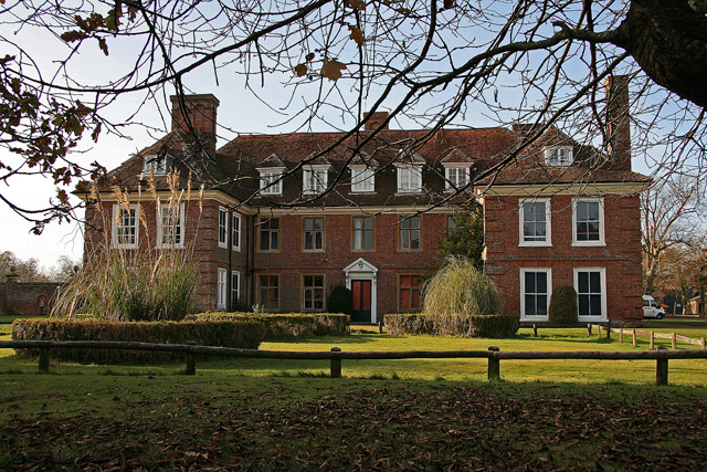
English: Moyles Court A Grade II* Listed late C17 country house, now a school. During the Second World War the house was requisitioned, and in 1940 fulfilled a new role as the station Headquarters for RAF Ibsley. Once the home of Lady Alice Lisle who was executed at Winchester in 1685 for harbouring two fugitives of Monmouth's army, after the Battle of Sedgemoor. The original sentence handed down by the notorious Judge Jeffreys was that of burning, but beheading was eventually substituted. She is buried at the nearby churchyard at Ellingham. |
| Date | |
| Source | From geograph.org.uk |
| Author | Mike Searle |
| Attribution (required by the license) | Mike Searle / Moyles Court / |
| Camera location | | View this and other nearby images on: OpenStreetMap |
|---|
_heading:247.00&language=en)
| Object location | | View this and other nearby images on: OpenStreetMap |
|---|
_heading:247.00&language=en)
Licensing

|
This image was taken from the Geograph project collection. See this photograph's page on the Geograph website for the photographer's contact details. The copyright on this image is owned by Mike Searle and is licensed for reuse under the Creative Commons Attribution-ShareAlike 2.0 license.
|
This file is licensed under the Creative Commons Attribution-Share Alike 2.0 Generic license.
Attribution: Mike Searle
- You are free:
- to share – to copy, distribute and transmit the work
- to remix – to adapt the work
- Under the following conditions:
- attribution – You must give appropriate credit, provide a link to the license, and indicate if changes were made. You may do so in any reasonable manner, but not in any way that suggests the licensor endorses you or your use.
- share alike – If you remix, transform, or build upon the material, you must distribute your contributions under the same or compatible license as the original.
File history
Click on a date/time to view the file as it appeared at that time.
| Date/Time | Thumbnail | Dimensions | User | Comment | |
|---|---|---|---|---|---|
| current | 06:26, 7 February 2011 | | 640 × 427 (195 KB) | GeographBot | == {{int:filedesc}} == {{Information |description={{en|1=Moyles Court A Grade II* Listed late C17 country house, now a school. During the Second World War the house was requisitioned, and in 1940 fulfilled a new role as the station Headquarters for RAF Ib |
File usage
The following pages on the English Wikipedia use this file (pages on other projects are not listed):
Global file usage
The following other wikis use this file:
- Usage on www.wikidata.org