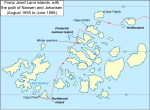
File:Nansen Franz Josef Land Voyage Map.PNG
Appearance

Size of this preview: 800 × 537 pixels. Other resolutions: 320 × 215 pixels | 640 × 430 pixels | 1,017 × 683 pixels.
Original file (1,017 × 683 pixels, file size: 118 KB, MIME type: image/png)
File history
Click on a date/time to view the file as it appeared at that time.
| Date/Time | Thumbnail | Dimensions | User | Comment | |
|---|---|---|---|---|---|
| current | 19:57, 11 October 2009 |  | 1,017 × 683 (118 KB) | Ruhrfisch | Add Eira Harbour, Cape Felden labels, all other info the same |
| 14:32, 9 October 2009 |  | 1,017 × 683 (116 KB) | Ruhrfisch | Add approximate distance scale, all other information is the same | |
| 18:59, 7 October 2009 |  | 1,017 × 683 (116 KB) | Ruhrfisch | Added directional arrow, all other information is the same | |
| 18:02, 7 October 2009 |  | 1,017 × 683 (115 KB) | Ruhrfisch | Larger labels, latitude lines and Winter quarters added, all other information is the same | |
| 04:58, 7 October 2009 |  | 1,019 × 655 (49 KB) | Ruhrfisch | {{Information |Description = Map of w:Franz Josef Land archipelago in the Arctic Ocean north of Russia, showing the path of Nansen and Johansen through the islands, August 1895 to June 1896 |Source = Base map is cropped from http://www.opens |
File usage
The following page uses this file:


