
File:North Korea launch site in Sea of Japan map - East Sea parentheses.png
No higher resolution available.
North_Korea_launch_site_in_Sea_of_Japan_map_-_East_Sea_parentheses.png (329 × 353 pixels, file size: 17 KB, MIME type: image/png)
| This is a file from the Wikimedia Commons. Information from its description page there is shown below. Commons is a freely licensed media file repository. You can help. |
| Description |
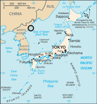
English: Map of Sea of Japan with circle locating North Korea Tonghae Satellite Launching Ground (previously Musudan-ri) and the text "East Sea" in parentheses after "Sea of Japan" |
|||
| Date | ||||
| Source | File:Japan sea map.png from the World CIA Factbook | |||
| Author | 84user added the circle, CIA made the map | |||
| Permission (Reusing this file) |
|
|||
| Other versions |
  |

File history
Click on a date/time to view the file as it appeared at that time.
| Date/Time | Thumbnail | Dimensions | User | Comment | |
|---|---|---|---|---|---|
| current | 00:58, 27 August 2010 | | 329 × 353 (17 KB) | 84user | {{Information |Description={{en|1=Map of Sea of Japan with circle locating North Korea Tonghae Satellite Launching Ground (previously Musudan-ri) and the text "East Sea" in parentheses after "Sea of Japan"}} |Source=[[:File:Japan sea |
File usage
No pages on the English Wikipedia use this file (pages on other projects are not listed).