
File:Old railway stations of Hamburg.svg

Size of this PNG preview of this SVG file: 544 × 600 pixels. Other resolutions: 218 × 240 pixels | 435 × 480 pixels | 696 × 768 pixels | 928 × 1,024 pixels | 1,857 × 2,048 pixels | 680 × 750 pixels.
Original file (SVG file, nominally 680 × 750 pixels, file size: 4 KB)
| This is a file from the Wikimedia Commons. Information from its description page there is shown below. Commons is a freely licensed media file repository. You can help. |
| Description |
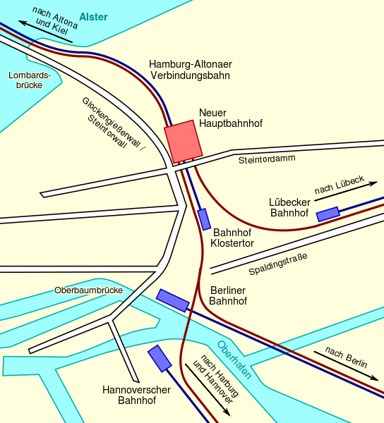
Deutsch: Diese Karte zeigt die historischen Endbahnhöfe in Hamburg: Den Lübecker, Berliner und Hannoverschen Bahnhof und den Bahnhof Klostertor sowie, in blau, die zu diesen Bahnhöfen führenden Eisenbahnstrecken. Weiterhin zeigt es den neuen Hauptbahnhof, der die alten Endbahnhöfe ersetzt, und (in braun) die neue Linienführung, welche die in Hamburg endenden Eisenbahnstrecken an den Hauptbahnhof heranführt.
English: This map shows the historic railways terminuses of Hamburg: Lübecker, Berliner, Hannoverscher Bahnhof, and Bahnhof Klostertor, and, in blue, the railway lines leading to these stations. It also shows the new Central Station that was built to replace these terminuses, and, in brown, the new railtrack arrangement connecting the Central Station to the railway lines ending in Hamburg. |
| Date | |
| Source |
Deutsch: Gezeichnet nach einer Vorlage von de:Benutzer:WHell, um diese zu ersetzen.
English: Drawn in accordance with, and in order to replace, a map of user de:Benutzer:WHell. |
| Author | Sebastian Koppehel, User:SKopp |
| Permission (Reusing this file) |
This file is licensed under the Creative Commons Attribution 2.0 Germany license.
 |
| Other versions |
|


File history
Click on a date/time to view the file as it appeared at that time.
| Date/Time | Thumbnail | Dimensions | User | Comment | |
|---|---|---|---|---|---|
| current | 14:11, 5 August 2012 | | 680 × 750 (4 KB) | Perhelion | bit stil, opt |
| 13:55, 5 August 2012 |  | 680 × 750 (5 KB) | Perhelion | fix: bigger font, opt | |
| 06:57, 22 February 2007 |  | 680 × 750 (48 KB) | SKopp | {{Information |Description=A map showing the old railway terminuses of Hamburg, and the new Central Station that replaced them. |Source=Drawn in accordance with de:Bild:HH-Bhf-hh.jpg |Date=2007-02-22 |Author=Sebastian Koppehel |Permission={{cc-by-2.0 |
File usage
No pages on the English Wikipedia use this file (pages on other projects are not listed).
Global file usage
The following other wikis use this file:
- Usage on de.wikipedia.org
- Usage on ja.wikipedia.org
- Usage on nl.wikipedia.org
- Usage on zh.wikipedia.org