
File:Parish church of St Wilfrid, Kirkby - geograph.org.uk - 243700.jpg
No higher resolution available.
Parish_church_of_St_Wilfrid,_Kirkby_-_geograph.org.uk_-_243700.jpg (640 × 480 pixels, file size: 108 KB, MIME type: image/jpeg)
| This is a file from the Wikimedia Commons. Information from its description page there is shown below. Commons is a freely licensed media file repository. You can help. |
Summary
| Description |
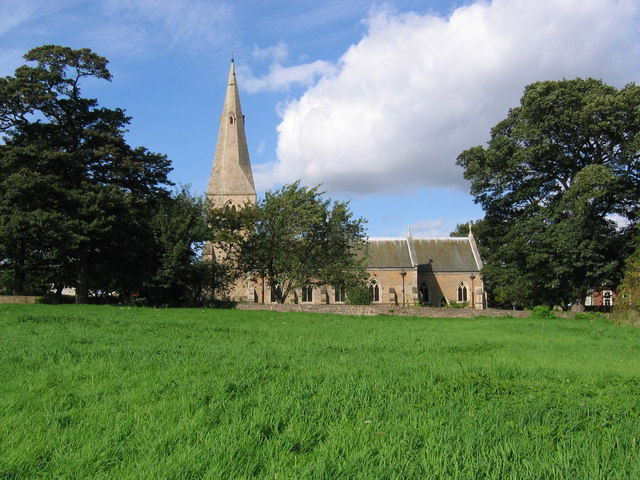
English: Parish church of St Wilfrid, Kirkby. The Church stands on an ancient site dating back to the 6th Century. The church was rebuilt in 1908 following a fire in 1907, which destroyed all but the tower and spire. The photograph was taken from the footpath to the south of the church and the grassy area in the foreground, known as Castle Hill, was the site of Kirkby Castle which pre-dated the Norman Conquest. |
| Date | |
| Source | From geograph.org.uk |
| Author | Nikki Mahadevan |
| Attribution (required by the license) | Nikki Mahadevan / Parish church of St Wilfrid, Kirkby / |
| Camera location | | View this and other nearby images on: OpenStreetMap |
|---|
_heading:0.00&language=en)
| Object location | | View this and other nearby images on: OpenStreetMap |
|---|
_heading:0.00&language=en)
Licensing

|
This image was taken from the Geograph project collection. See this photograph's page on the Geograph website for the photographer's contact details. The copyright on this image is owned by Nikki Mahadevan and is licensed for reuse under the Creative Commons Attribution-ShareAlike 2.0 license.
|
This file is licensed under the Creative Commons Attribution-Share Alike 2.0 Generic license.
Attribution: Nikki Mahadevan
- You are free:
- to share – to copy, distribute and transmit the work
- to remix – to adapt the work
- Under the following conditions:
- attribution – You must give appropriate credit, provide a link to the license, and indicate if changes were made. You may do so in any reasonable manner, but not in any way that suggests the licensor endorses you or your use.
- share alike – If you remix, transform, or build upon the material, you must distribute your contributions under the same or compatible license as the original.
File history
Click on a date/time to view the file as it appeared at that time.
| Date/Time | Thumbnail | Dimensions | User | Comment | |
|---|---|---|---|---|---|
| current | 16:02, 1 February 2010 | | 640 × 480 (108 KB) | GeographBot | == {{int:filedesc}} == {{Information |description={{en|1=Parish church of St Wilfrid, Kirkby. The Church stands on an ancient site dating back to the 6th Century. The church was rebuilt in 1908 following a fire in 1907, which destroyed all but the tower a |
File usage
The following pages on the English Wikipedia use this file (pages on other projects are not listed):
Global file usage
The following other wikis use this file:
- Usage on fr.wikipedia.org
- Usage on www.wikidata.org