Jump to content

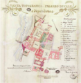
File:Parma Palazzo Ducale - Map of surroundings in 1841.png

Page contents not supported in other languages.
This is a file from the Wikimedia Commons
From Wikipedia, the free encyclopedia

Original file(731 × 751 pixels, file size: 784 KB, MIME type: image/png)

Summary

Description
English: The construction is reproduced in the topographical plan of 1841 of the development project for the entire Pilotta area, ibid including the Ducal Palace and the entire system of relations with the buildings connected to it, designed by the architect. Nicola Bettoli; to the north of the Piazza di Corte the vast plane tree is depicted (Archivio di Stato di Parma, Patrimonio dello Stato, busta 6, mappa 650).
Date
Source http://www.pubblicigiardini.it/wp-content/uploads/2015/04/Antichi_Platani.pdf
Author Nicola Bettoli

Licensing

Public domain

This work is in the public domain in its country of origin and other countries and areas where the copyright term is the author's life plus 70 years or fewer.


You must also include a United States public domain tag to indicate why this work is in the public domain in the United States.

Captions

Plan of the surroundings of the Ducal palace of Parma in 1841

Items portrayed in this file

depicts

image/png

File history

Click on a date/time to view the file as it appeared at that time.

Date/TimeThumbnailDimensionsUserComment
current12:29, 2 April 2024Thumbnail for version as of 12:29, 2 April 2024731 × 751 (784 KB)IpfloUploaded a work by Nicola Bettoli from http://www.pubblicigiardini.it/wp-content/uploads/2015/04/Antichi_Platani.pdf with UploadWizard
The following pages on the English Wikipedia use this file (pages on other projects are not listed):

Metadata