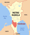
File:Ph locator ncr paranaque.png
Appearance
Ph_locator_ncr_paranaque.png (300 × 352 pixels, file size: 10 KB, MIME type: image/png)
File history
Click on a date/time to view the file as it appeared at that time.
| Date/Time | Thumbnail | Dimensions | User | Comment | |
|---|---|---|---|---|---|
| current | 13:44, 31 October 2017 |  | 300 × 352 (10 KB) | Hariboneagle927 | South Manila Cemetery exclave (Manila) |
| 13:44, 23 November 2013 |  | 300 × 352 (23 KB) | User 50 | ||
| 05:51, 2 September 2005 |  | 300 × 352 (8 KB) | Magalhães | Map of Metro Manilla showing the location of Paranaque Source: [http://en.wikipedia.org/wiki/Image:Ph_locator_ncr_paranaque.png English wikipedia] {{GFDL}} Category:Maps of Metro Manilla\ |
File usage
The following 2 pages use this file:
Global file usage
The following other wikis use this file:
- Usage on ceb.wikipedia.org
- Usage on eo.wikipedia.org
- Usage on fr.wikipedia.org
- Usage on id.wikipedia.org
- Usage on ilo.wikipedia.org
- Usage on incubator.wikimedia.org
- Usage on it.wikipedia.org
- Usage on ja.wikipedia.org
- Usage on ko.wikipedia.org
- Usage on no.wikipedia.org
- Usage on sco.wikipedia.org
- Usage on sv.wikipedia.org
- Usage on tl.wikipedia.org
- Usage on ur.wikipedia.org
- Usage on vi.wikipedia.org
- Usage on war.wikipedia.org
- Usage on www.wikidata.org
- Usage on zh-yue.wikipedia.org


