
File:Pine Nut Mountains, Nevada (18012724188).jpg

Original file (4,000 × 3,000 pixels, file size: 2.91 MB, MIME type: image/jpeg)
| This is a file from the Wikimedia Commons. Information from its description page there is shown below. Commons is a freely licensed media file repository. You can help. |
.jpg)
Summary
| Description |
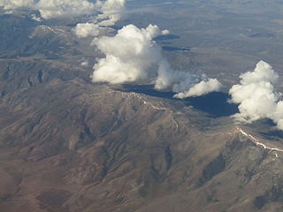
The Pine Nut Mountains are a north-south mountain range in the Great Basin, in Storey County of northwestern Nevada, United States. The highest mountain in the range is Mount Siegel at 9,456 ft (2,882 m). The range starts in the north at the Virginia Range (famous for Virginia City and the Comstock Lode). They continue south for approximately 40 miles where they join with the Sierra Nevada near Topaz Lake and Leviathan Peak. They are bounded on the west by the Carson Valley and to the east by Mason Valley. The Pine Nut Mountains take their name from the Single-leaf pinyon pines that dominate the slopes between 5000–7000 ft. This is mixed with juniper to form the standard Pinyon-juniper woodland plant community. Lower slopes are dominated by Sage-Juniper. The Pine Nut Mountains have been used throughout history by a number of groups for various purposes. The Washoe tribe used (and still uses) the vast quantities of Pinyon pine for the nuts as a staple in their diet. The nuts were collected, roasted, and cached during the fall for use during the lean months of winter. After the discovery of silver and gold in the area, the Pine Nut Mountains became a key source of timber for the building boom and charcoal for the smelters, thus depleting many of the traditional Washoe collection areas. Today, the range is still used by the Washoe for traditional purposes as well as hikers, hunters, and other outdoor enthusiasts. en.wikipedia.org/wiki/Pine_Nut_Mountains en.wikipedia.org/wiki/Wikipedia:Text_of_Creative_Commons_... |
| Date | |
| Source | Pine Nut Mountains, Nevada |
| Author | Ken Lund from Reno, Nevada, USA |
| Camera location | | View this and other nearby images on: OpenStreetMap |
|---|
.jpg¶ms=039.197152_N_-119.462039_E_globe:Earth_type:camera_source:Flickr_&language=en)
Licensing
- You are free:
- to share – to copy, distribute and transmit the work
- to remix – to adapt the work
- Under the following conditions:
- attribution – You must give appropriate credit, provide a link to the license, and indicate if changes were made. You may do so in any reasonable manner, but not in any way that suggests the licensor endorses you or your use.
- share alike – If you remix, transform, or build upon the material, you must distribute your contributions under the same or compatible license as the original.
| This image was originally posted to Flickr by Ken Lund at https://flickr.com/photos/75683070@N00/18012724188. It was reviewed on 4 December 2015 by FlickreviewR and was confirmed to be licensed under the terms of the cc-by-sa-2.0. |
File history
Click on a date/time to view the file as it appeared at that time.
| Date/Time | Thumbnail | Dimensions | User | Comment | |
|---|---|---|---|---|---|
| current | 04:33, 4 December 2015 | | 4,000 × 3,000 (2.91 MB) | INeverCry | Transferred from Flickr via Flickr2Commons |
.jpg)