
File:Pitons du Carbet.jpg

Size of this preview: 800 × 600 pixels. Other resolutions: 320 × 240 pixels | 640 × 480 pixels | 1,024 × 768 pixels | 1,280 × 960 pixels | 2,560 × 1,920 pixels | 3,264 × 2,448 pixels.
Original file (3,264 × 2,448 pixels, file size: 3.95 MB, MIME type: image/jpeg)
| This is a file from the Wikimedia Commons. Information from its description page there is shown below. Commons is a freely licensed media file repository. You can help. |
Summary
| Camera location | | View this and other nearby images on: OpenStreetMap |
|---|
| Description |
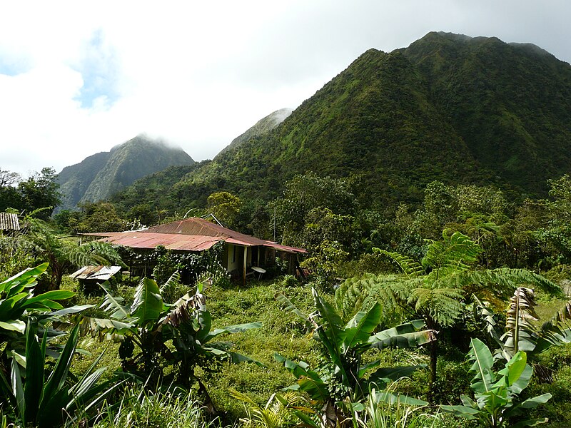
English: Carbet Mountains as seen from Plateau du Boucher, Martinique. From right to left: Piton Boucher, Piton Lacroix and Piton de l'Alma Deutsch: Pitons du Carbet vom Plateu du Boucher aus, Martinique. Von rechts nach links Piton Boucher, Piton Lacroix und Piton de l'Alma Polski: Pitons du Carbet widziane z Plateau du Boucher, Martynika. Od lewej do prawej: Piton Boucher, Piton Lacroix i Piton de l'Alma |
| Date | originally uploaded on 24.02.2009 |
| Source | Own work originally uploaded on German Wikipedia |
| Author | Rsddrs |
Licensing
This file is licensed under the Creative Commons Attribution-Share Alike 3.0 Unported license.
- You are free:
- to share – to copy, distribute and transmit the work
- to remix – to adapt the work
- Under the following conditions:
- attribution – You must give appropriate credit, provide a link to the license, and indicate if changes were made. You may do so in any reasonable manner, but not in any way that suggests the licensor endorses you or your use.
- share alike – If you remix, transform, or build upon the material, you must distribute your contributions under the same or compatible license as the original.
Original upload log
The original description page was here. All following user names refer to de.wikipedia.
- 2009-02-24 13:35 Rsddrs 3264×2448× (4146102 bytes) {{Information |Beschreibung = Pitons du Carbet |Quelle = own picture |Urheber = rsddrs |Datum = 24.02.2009 |Genehmigung = Bild-CC-by-sa/3.0 |Andere Versionen = |Anmerkungen = }} {{Bild-CC-by-sa/3.0}}
File history
Click on a date/time to view the file as it appeared at that time.
| Date/Time | Thumbnail | Dimensions | User | Comment | |
|---|---|---|---|---|---|
| current | 10:16, 16 March 2009 | | 3,264 × 2,448 (3.95 MB) | Botev | {{Information |Description={{en|Pitons du Carbet as seen from Plateu du Boucher, Martinique. From right to left: Piton Boucher, Piton Lacroix und Piton de l'Alma}}{{de|Pitos du Carbet vom Plateu du Boucher aus, Martinique. Von rechts nach links Piton Bouc |
File usage
No pages on the English Wikipedia use this file (pages on other projects are not listed).
Global file usage
The following other wikis use this file:
- Usage on cs.wikipedia.org
- Usage on de.wikipedia.org
- Usage on es.wikipedia.org
- Usage on lt.wikipedia.org
- Usage on www.wikidata.org