
File:Plan af fæstningen Rendsborg omkring 1720.jpg

Size of this preview: 485 × 599 pixels. Other resolutions: 194 × 240 pixels | 389 × 480 pixels | 622 × 768 pixels | 829 × 1,024 pixels | 1,658 × 2,048 pixels | 5,117 × 6,319 pixels.
Original file (5,117 × 6,319 pixels, file size: 8.84 MB, MIME type: image/jpeg)
| This is a file from the Wikimedia Commons. Information from its description page there is shown below. Commons is a freely licensed media file repository. You can help. |
Summary
| Description |
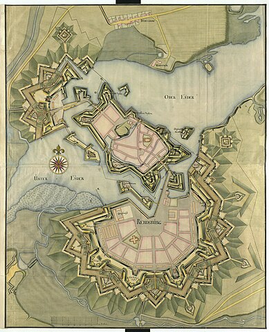
English: A map of Rendsburg's fortifications from Frederik V's Atlas |
| Date | between 1700 and 1750 |
| Source | http://kb-images.kb.dk/DAMJP2/DAM/Maps/0000/077/236/fr529053/full/full/0/native.jpg |
| Author | Frederik den Femtes Atlas, Bd. 29, Tvl. 53 |
Licensing
|
This work is in the public domain in its country of origin and other countries and areas where the copyright term is the author's life plus 70 years or fewer. | |
| This file has been identified as being free of known restrictions under copyright law, including all related and neighboring rights. | |
This is a Danish map of Rendsburg from between 1700 and 1750 that was a part of a royal atlas. It has been published by the Danish Royal Library on their website, where they state that it is for free use.
File history
Click on a date/time to view the file as it appeared at that time.
| Date/Time | Thumbnail | Dimensions | User | Comment | |
|---|---|---|---|---|---|
| current | 20:53, 11 September 2023 | | 5,117 × 6,319 (8.84 MB) | Admiral Fisker | Uploaded a work by Frederik den Femtes Atlas, Bd. 29, Tvl. 53 from http://kb-images.kb.dk/DAMJP2/DAM/Maps/0000/077/236/fr529053/full/full/0/native.jpg with UploadWizard |
File usage
The following pages on the English Wikipedia use this file (pages on other projects are not listed):