
File:Port louis map 1774.jpg
No higher resolution available.
Port_louis_map_1774.jpg (276 × 200 pixels, file size: 12 KB, MIME type: image/jpeg)
| This is a file from the Wikimedia Commons. Information from its description page there is shown below. Commons is a freely licensed media file repository. You can help. |
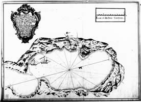
Summary
| Description | Map of Port Louis, surveyed in 1774 |
| Date | Unknown date |
| Source | http://www.liverpoolmuseums.org.uk/mol/archaeology/field/projects/falklands/port_louis_survey.aspx |
| Author | Unknown author |
| Permission (Reusing this file) |
Pd-Expired |
Licensing
|
This work is in the public domain in its country of origin and other countries and areas where the copyright term is the author's life plus 70 years or fewer. | |
| This file has been identified as being free of known restrictions under copyright law, including all related and neighboring rights. | |
File history
Click on a date/time to view the file as it appeared at that time.
| Date/Time | Thumbnail | Dimensions | User | Comment | |
|---|---|---|---|---|---|
| current | 17:58, 31 October 2008 | | 276 × 200 (12 KB) | RaviC | == Summary == {{Information |Description=Map of Port Louis, surveyed in 1774 |Source=http://www.liverpoolmuseums.org.uk/mol/archaeology/field/projects/falklands/port_louis_survey.aspx |Date=? |Author=Unknown |Permission=Pd-Expired |other_versions= }} <!-- |
File usage
The following pages on the English Wikipedia use this file (pages on other projects are not listed):
Global file usage
The following other wikis use this file:
- Usage on es.wikipedia.org
- Usage on fr.wikipedia.org
- Usage on pt.wikipedia.org