
File:Providence Metro Area.png
No higher resolution available.
Providence_Metro_Area.png (640 × 416 pixels, file size: 47 KB, MIME type: image/png)
| This is a file from the Wikimedia Commons. Information from its description page there is shown below. Commons is a freely licensed media file repository. You can help. |
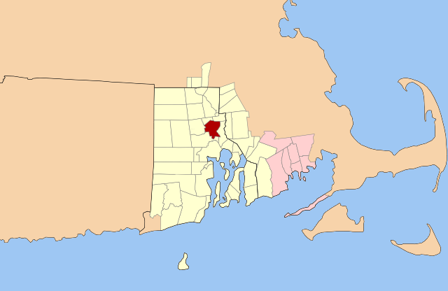
| Description | Map of the Providence (yellow) and New Bedford (pink) New England City and Town Areas. (Metropolitan Statistical Areas are defined at the county level; NECTAs are defined with municipal granularity.) The City of Providence is highlighted (red). |
| Date | |
| Source | Original outline map from Libre Map Project |
| Author | Justin H. Petrosek |
I, the copyright holder of this work, hereby publish it under the following licenses:

|
Permission is granted to copy, distribute and/or modify this document under the terms of the GNU Free Documentation License, Version 1.2 or any later version published by the Free Software Foundation; with no Invariant Sections, no Front-Cover Texts, and no Back-Cover Texts. A copy of the license is included in the section entitled GNU Free Documentation License. |
This file is licensed under the Creative Commons Attribution-Share Alike 3.0 Unported, 2.5 Generic, 2.0 Generic and 1.0 Generic license.
- You are free:
- to share – to copy, distribute and transmit the work
- to remix – to adapt the work
- Under the following conditions:
- attribution – You must give appropriate credit, provide a link to the license, and indicate if changes were made. You may do so in any reasonable manner, but not in any way that suggests the licensor endorses you or your use.
- share alike – If you remix, transform, or build upon the material, you must distribute your contributions under the same or compatible license as the original.
You may select the license of your choice.
File history
Click on a date/time to view the file as it appeared at that time.
| Date/Time | Thumbnail | Dimensions | User | Comment | |
|---|---|---|---|---|---|
| current | 08:43, 24 April 2008 | | 640 × 416 (47 KB) | File Upload Bot (Petros63) | {{Information|Description=Map of the Providence (yellow) and New Bedford (pink) Metropolitan Areas. The City of Providence is highlighted (red).|Source=Original outline map from [http://libremap.org/data/boundary/ Libre Map Project]|Date=2008-04-24|Autho |
| 04:25, 10 September 2007 |  | 800 × 520 (150 KB) | File Upload Bot (Petros63) | {{Information|Description=Map of the Providence (blue) and New Bedford (purple) Metropolitan Areas. The City of Providence is highlighted (red).|Source=Original outline map from [http://libremap.org/data/boundary/ Libre Map Project]|Date=2007-09-02|Autho | |
| 04:35, 3 September 2007 |  | 800 × 520 (113 KB) | File Upload Bot (Petros63) | {{Information|Description=Map of the Providence (blue) and New Bedford (purple) Metropolitan Areas. The City of Providence is highlighted (red).|Source=Original outline map from [http://libremap.org/data/boundary/ Libre Map Project]|Date=2007-09-02|Autho | |
| 04:30, 3 September 2007 |  | 800 × 520 (132 KB) | File Upload Bot (Petros63) | {{Information|Description=Map of the Providence (blue) and New Bedford (purple) Metropolitan Areas. The City of Providence is highlighted (red).|Source=Original outline map from [http://libremap.org/data/boundary/ Libre Map Project]|Date=2007-09-02|Autho |
File usage
No pages on the English Wikipedia use this file (pages on other projects are not listed).
Global file usage
The following other wikis use this file:
- Usage on es.wikipedia.org
- Usage on fa.wikipedia.org
- Usage on ur.wikipedia.org
- Usage on www.wikidata.org