
File:Rashidun654wVassal.png

Size of this preview: 800 × 487 pixels. Other resolutions: 320 × 195 pixels | 640 × 390 pixels | 1,024 × 624 pixels | 1,481 × 902 pixels.
Original file (1,481 × 902 pixels, file size: 49 KB, MIME type: image/png)
| This is a file from the Wikimedia Commons. Information from its description page there is shown below. Commons is a freely licensed media file repository. You can help. |
Summary
| Description |
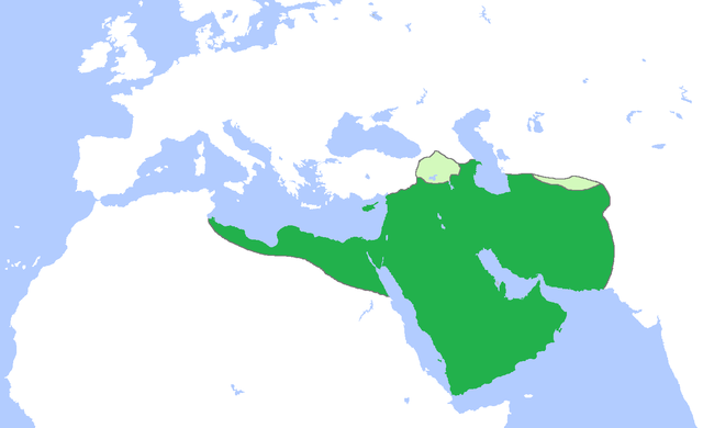
English: Map of the Rashidun Caliphate (dark green) with vassal states (light green), c. 654.
(Partially based on several other Wikimedia Commons maps of the Rashidun Caliphate). |
| Date | |
| Source | Own work |
| Author | Gabagool |
Licensing
I, the copyright holder of this work, hereby publish it under the following license:
This file is licensed under the Creative Commons Attribution 3.0 Unported license.
- You are free:
- to share – to copy, distribute and transmit the work
- to remix – to adapt the work
- Under the following conditions:
- attribution – You must give appropriate credit, provide a link to the license, and indicate if changes were made. You may do so in any reasonable manner, but not in any way that suggests the licensor endorses you or your use.
File history
Click on a date/time to view the file as it appeared at that time.
| Date/Time | Thumbnail | Dimensions | User | Comment | |
|---|---|---|---|---|---|
| current | 09:41, 17 June 2012 | | 1,481 × 902 (49 KB) | Cplakidas | further corrections: Western Georgia remained under Byz. control, Armenia and Iberia were vassals, but the Exarchate of Carthage was not |
| 01:48, 12 October 2010 |  | 1,481 × 902 (47 KB) | Cplakidas | corrections: the Exarchate of Carthage extended only around mod. northern Tunisia at the time, Rhodes, Crete and Sicily were raided but not occupied, and Cilicia, the region of the northern Euphrates and western Armenia were not yet conquered. | |
| 16:07, 21 April 2009 |  | 1,481 × 902 (49 KB) | Gabagool | {{Information |Description={{en|1=Map of the Rashidun Caliphate (dark green) with vassal states (light green), c. 654. (Partially based on several other Wikimedia Commons maps of the Rashidun Caliphate).}} |Source=Own work by uploader |Author=[[User:Gaba |
File usage
The following pages on the English Wikipedia use this file (pages on other projects are not listed):
- User:-Jafar277-
- User:Arab Hafez
- User:Asianadrian
- User:Bolt Escargot
- User:BomBom/List of caliphs
- User:Carthago814
- User:CarvigoLD
- User:Dhaouadi bizerte
- User:Euripides ψ
- User:Falcaorib
- User:Felineastatine
- User:Idriskamal
- User:Katafada
- User:Khalid Nezami/sandbox
- User:Knowledgepocket
- User:Kursemaster
- User:Latristelagrima
- User:LeftAire/Islamic Caliphates
- User:Malkawi99
- User:Mohamed Taqi
- User:Nahiyan567
- User:Nayefc
- User:NordVPN Man
- User:Ph1ne4s
- User:Pianist4
- User:Sabbir31x/Userboxes3
- User:Sira Aspera
- User:Sj122390
- User:Sobreira/Religion
- User:Solavirum/about
- User:Srpbm
- User:TomReagan90
- User:VFF0347
- User:WarriorofShiism
- User:Yulin Zhang
- Wikipedia:Userboxes/History/Empires
Global file usage
The following other wikis use this file:
- Usage on ar.wikipedia.org
- Usage on arz.wikipedia.org
- Usage on az.wikipedia.org
- Usage on ba.wikipedia.org
- Usage on bn.wikipedia.org
- Usage on ca.wikipedia.org
- Usage on da.wikipedia.org
- Usage on el.wikipedia.org
- Usage on es.wikipedia.org
- Usage on eu.wikipedia.org
- Usage on fi.wikipedia.org
- Usage on hr.wikipedia.org
- Usage on hu.wikipedia.org
- Usage on hy.wikipedia.org
- Usage on id.wikipedia.org
- Usage on incubator.wikimedia.org
- Usage on it.wikipedia.org
- Usage on ja.wikipedia.org
- Usage on jv.wikipedia.org
- Usage on kk.wikipedia.org
- Usage on ko.wikipedia.org
View more global usage of this file.