
File:Redcliffe–maud map.png

Size of this preview: 678 × 599 pixels. Other resolutions: 272 × 240 pixels | 543 × 480 pixels | 776 × 686 pixels.
Original file (776 × 686 pixels, file size: 28 KB, MIME type: image/png)
Summary[edit]
| Description |
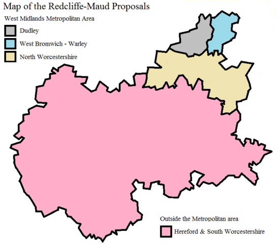
Map of the Redcliffe–Maud proposals for Worcestershire and surrounding areas of Herefordshire and South Staffordshire. |
|---|---|
| Source |
created this map on my own using basic software |
| Date |
2016-06-30 |
| Author | |
| Permission (Reusing this file) |
See below.
|
- Other information
N/A
Licensing[edit]
I, the copyright holder of this work, hereby publish it under the following licenses:
 | Permission is granted to copy, distribute and/or modify this document under the terms of the GNU Free Documentation License, Version 1.2 or any later version published by the Free Software Foundation; with no Invariant Sections, no Front-Cover Texts, and no Back-Cover Texts. |
| This work is licensed under the Creative Commons Attribution-ShareAlike 3.0 License. |
You may select the license of your choice.
File history
Click on a date/time to view the file as it appeared at that time.
| Date/Time | Thumbnail | Dimensions | User | Comment | |
|---|---|---|---|---|---|
| current | 00:12, 30 June 2013 | | 776 × 686 (28 KB) | Bellow558 (talk | contribs) | tidying up |
| 23:50, 29 June 2013 |  | 776 × 686 (28 KB) | Bellow558 (talk | contribs) | Reverted to version as of 23:48, 29 June 2013 | |
| 23:49, 29 June 2013 |  | 776 × 686 (35 KB) | Bellow558 (talk | contribs) | Reverted to version as of 23:18, 29 June 2013 | |
| 23:48, 29 June 2013 |  | 776 × 686 (28 KB) | Bellow558 (talk | contribs) | Town labelling removed | |
| 23:18, 29 June 2013 |  | 776 × 686 (35 KB) | Bellow558 (talk | contribs) | Uploading a self-made file using File Upload Wizard |
You cannot overwrite this file.
File usage
The following pages on the English Wikipedia use this file (pages on other projects are not listed):