
File:Research triangle.PNG
No higher resolution available.
Research_triangle.PNG (654 × 266 pixels, file size: 29 KB, MIME type: image/png)
| This is a file from the Wikimedia Commons. Information from its description page there is shown below. Commons is a freely licensed media file repository. You can help. |
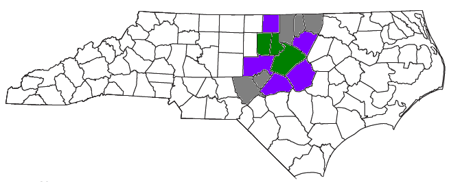
| Description | Locator map of the The Research Triangle region of the US State of North Carolina culled from several sources, including the U.S. Census Bureau, the Triangle J Council of Governments, the Research Triangle Regional Partnership, and the Research Triangle Foundation of North Carolina Green is the three core counties, purple is the U.S. Census Bureau definition, and gray is the definitions based on other sources. |
| Date | (UTC) |
| Source | |
| Author |
|
| This is a retouched picture, which means that it has been digitally altered from its original version. Modifications: Recolored original map to include other sources.. The original can be viewed here: Raleigh-Durham-Cary CSA.png:
|
I, the copyright holder of this work, hereby publish it under the following license:
| I, the copyright holder of this work, release this work into the public domain. This applies worldwide. In some countries this may not be legally possible; if so: I grant anyone the right to use this work for any purpose, without any conditions, unless such conditions are required by law. |
Original upload log
This image is a derivative work of the following images:
- File:Raleigh-Durham-Cary_CSA.png licensed with PD-self
- 2008-07-28T15:37:06Z Nyttend 654x266 (29361 Bytes) {{Information |Description=Locator map of the {{w|The Triangle (North Carolina)|Raleigh-Durham-Cary}} {{w|Combined Statistical Area}} in the north central part of the {{w|U.S. state}} of {{w|North Carolina}}. The three compo
Uploaded with derivativeFX
File history
Click on a date/time to view the file as it appeared at that time.
| Date/Time | Thumbnail | Dimensions | User | Comment | |
|---|---|---|---|---|---|
| current | 18:17, 17 March 2010 | 654 × 266 (29 KB) | Jayron32 | {{Information |Description=Locator map of the {{w|The Research Triangle}} region of the US State of {{w|North Carolina}} culled from several sources, including [http://www2.census.gov/geo/maps/general_ref/cousub_outline/cen2k_pgsz/nc_cosub.pdf the U.S. Ce |
File usage
No pages on the English Wikipedia use this file (pages on other projects are not listed).