
File:Salan glad01.png

Size of this preview: 723 × 599 pixels. Other resolutions: 290 × 240 pixels | 579 × 480 pixels | 1,018 × 844 pixels.
Original file (1,018 × 844 pixels, file size: 75 KB, MIME type: image/png)
| This is a file from the Wikimedia Commons. Information from its description page there is shown below. Commons is a freely licensed media file repository. You can help. |
Summary
| Description |
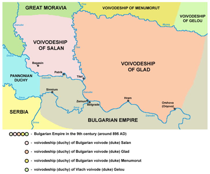
English: historical map of medieval duchies of Bulgarian dukes Salan and Glad (9th century)
Српски / srpski: историјска карта средњовековних војводстава бугарских војвода Салана и Глада (9. век) |
| Date | 28 December 2006 (original upload date) |
| Source | Own work |
| Author | PANONIAN |
References
Published references:
- Dr Aleksa Ivić, Istorija Srba u Vojvodini, Novi Sad, 1929.
- Milan Tutorov, Mala Raška a u Banatu, Zrenjanin, 1991.
- Milan Tutorov, Banatska rapsodija - istorika Zrenjanina i Banata, Novi Sad, 2001.
- Radmilo Petrović, Vojvodina - petnaest milenijuma kulturne istorije, Beograd, 2003.
- Njagu Đuvara, Kratka istorija Rumuna za mlade, Novi Sad, 2004.
- Jovan Pejin, Velikomađarski kapric, Zrenjanin, 2007.
- Marko Jovanov, Devet vekova od pomena imena Titela, Titelski letopis, Titel, 2001.
- Dušan Belča, Mala istorija Vršca, Vršac, 1997.
- Istorijski atlas, Zavod za udžbenike i nastavna sredstva - Zavod za kartografiju "Geokarta", Beograd, 1999.
- Petrit Imami, Srbi i Albanci kroz vekove, Beograd, 2000.
Internet references:
- Duchies of Salan and Glad - map (curug.rastko.net) archive copy at the Wayback Machine
- Duchy of Glad - map (www.eliznik.org.uk)
Source and licence
self made map by user:PANONIAN

|
This map has been uploaded by Electionworld from en.wikipedia.org to enable the |
Licensing
| I, the copyright holder of this work, release this work into the public domain. This applies worldwide. In some countries this may not be legally possible; if so: I grant anyone the right to use this work for any purpose, without any conditions, unless such conditions are required by law. |
File history
Click on a date/time to view the file as it appeared at that time.
| Date/Time | Thumbnail | Dimensions | User | Comment | |
|---|---|---|---|---|---|
| current | 10:17, 11 May 2014 | | 1,018 × 844 (75 KB) | PANONIAN | aesthetics |
| 13:06, 20 April 2010 |  | 1,020 × 844 (75 KB) | PANONIAN | aesthetical correction | |
| 13:32, 29 July 2009 |  | 1,020 × 844 (75 KB) | PANONIAN | ||
| 23:21, 17 March 2009 |  | 549 × 425 (36 KB) | PANONIAN | ||
| 18:54, 28 December 2006 |  | 580 × 632 (42 KB) | Electionworld | {{ew|en|PANONIAN}} historic map (self made) {{PD-self}} Category:Maps of the history of Romania Category:Maps of the history of Serbia Category:Maps of the history of Vojvodina |
File usage
The following pages on the English Wikipedia use this file (pages on other projects are not listed):
Global file usage
The following other wikis use this file:
- Usage on bg.wikipedia.org
- Usage on ca.wikipedia.org
- Usage on el.wikipedia.org
- Usage on fr.wikipedia.org
- Usage on gl.wikipedia.org
- Usage on he.wikipedia.org
- Usage on it.wikipedia.org
- Usage on ja.wikipedia.org
- Usage on lt.wikipedia.org
- Usage on pl.wikipedia.org
- Usage on pl.wiktionary.org
- Usage on ro.wikipedia.org
- Usage on ru.wikipedia.org
- Usage on sh.wikipedia.org
- Usage on sr.wikipedia.org