
File:Satellite Image of Hiddensee.jpg

Size of this preview: 459 × 599 pixels. Other resolutions: 184 × 240 pixels | 368 × 480 pixels | 694 × 906 pixels.
Original file (694 × 906 pixels, file size: 97 KB, MIME type: image/jpeg)
| This is a file from the Wikimedia Commons. Information from its description page there is shown below. Commons is a freely licensed media file repository. You can help. |
| Description | ||||
| Date | ||||
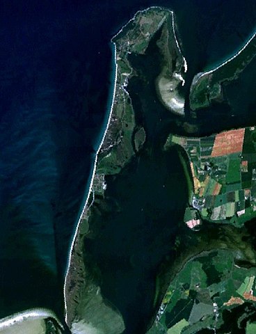
| Source | NASA Landsat 7 Image (Visible Color) | |||
| Author | NASA | |||
| Permission (Reusing this file) |
|

File history
Click on a date/time to view the file as it appeared at that time.
| Date/Time | Thumbnail | Dimensions | User | Comment | |
|---|---|---|---|---|---|
| current | 00:26, 5 June 2005 | | 694 × 906 (97 KB) | BLueFiSH.as | {{german}} '''Beschreibung''': Satellitenbild von Hiddensee {{english}} '''Description''': Satellite Image of Hiddensee {{french}} '''Légende''': Photo satellite de [[:Category:Hidde |
File usage
The following pages on the English Wikipedia use this file (pages on other projects are not listed):
Global file usage
The following other wikis use this file:
- Usage on ar.wikipedia.org
- Usage on cs.wikipedia.org
- Usage on de.wikipedia.org
- Usage on de.wikinews.org
- Usage on fa.wikipedia.org
- Usage on fr.wikipedia.org
- Usage on ka.wikipedia.org
- Usage on mk.wikipedia.org
- Usage on nn.wikipedia.org
- Usage on no.wikipedia.org
- Usage on pl.wikipedia.org
- Usage on ru.wikipedia.org
- Usage on sl.wikipedia.org
- Usage on sv.wikipedia.org
- Usage on uk.wikipedia.org
- Usage on vi.wikipedia.org