
File:Scarborough Centre (riding map).png

Size of this preview: 499 × 600 pixels. Other resolutions: 200 × 240 pixels | 399 × 480 pixels | 639 × 768 pixels | 1,030 × 1,238 pixels.
Original file (1,030 × 1,238 pixels, file size: 200 KB, MIME type: image/png)
| This is a file from the Wikimedia Commons. Information from its description page there is shown below. Commons is a freely licensed media file repository. You can help. |
.png)
Summary
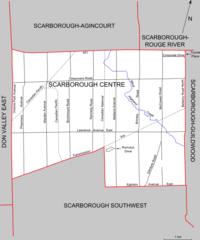
| Description | Map of the Ontario federal and provincial riding of Scarborough Centre (boundaries defined federally in 2003 and adopted provincially in 2007) |
| Date | |
| Source | Self-made (based on map at Elections Canada web site) |
| Author | Slyguy |
Licensing
| I, the copyright holder of this work, release this work into the public domain. This applies worldwide. In some countries this may not be legally possible; if so: I grant anyone the right to use this work for any purpose, without any conditions, unless such conditions are required by law. |
File history
Click on a date/time to view the file as it appeared at that time.
| Date/Time | Thumbnail | Dimensions | User | Comment | |
|---|---|---|---|---|---|
| current | 16:41, 10 January 2008 | | 1,030 × 1,238 (200 KB) | Slyguy~commonswiki | {{Information |Description=Map of the Canadian federal political riding of Scarborough Centre (2003 boundaries) |Source=Self-made (based on [http://www.elections.ca/scripts/pss/PopUpWindows.asp?ED=35081 map at Elections Canada web site]) |Date=January 10, |
File usage
No pages on the English Wikipedia use this file (pages on other projects are not listed).
.png)