File:ScotlandHighlands.png
Appearance
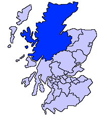
ScotlandHighlands.png (200 × 230 pixels, file size: 4 KB, MIME type: image/png)
File history
Click on a date/time to view the file as it appeared at that time.
| Date/Time | Thumbnail | Dimensions | User | Comment | |
|---|---|---|---|---|---|
| current | 21:36, 17 May 2005 |  | 200 × 230 (4 KB) | Voyager | Highland unitary council Slightly edited version of a map drawn by Morwen {{GFDL}} Category:Maps of Scottish unitary councils |
File usage
The following 10 pages use this file:
- Caithness
- Highland Council Wards in 2017
- Highland Council wards 1995 to 1999
- Highland Council wards 1999 to 2007
- Highland Council wards and councillors 1999 to 2003
- Highland Council wards and councillors 2003 to 2007
- Highland Council wards created in 2007
- Wikipedia:GLAM/SLIC/Library Partners
- Category:Highland articles missing geocoordinate data
- Category:Scotland articles missing geocoordinate data
Global file usage
The following other wikis use this file:
- Usage on ast.wikipedia.org
- Usage on be.wikipedia.org
- Usage on bg.wikipedia.org
- Usage on br.wikipedia.org
- Usage on cy.wikipedia.org
- Usage on da.wikipedia.org
- Usage on eu.wikipedia.org
- Inverness
- Highland
- Eskoziako Lur Garaiak
- Fort William (Eskozia)
- Eilean Donan
- Lankide:Euskaldunaa
- Kyle of Lochalsh
- Ullapool
- Nairn
- Portree
- Broadford (Eskozia)
- John o' Groats
- Kingussie
- Aviemore
- Kyleakin
- Glenfinnan
- Dornoch
- Thurso (Eskozia)
- Txantiloi:Highland
- Alness
- Brora
- Dingwall
- Fortrose
- Grantown-on-Spey
- Invergordon
- Inverlochy (Highland)
- Mallaig
- Tain
- Wick (Caithness)
- Abernethy and Kincardine
- Achnahannet (Strathspey)
- Advie
- Alvie
- Arpafeelie
- Artafallie
- Aundorach
- Avielochan
- Avoch
- Boat of Garten
- Bogroy
- Bishop Kinkell
- Carrbridge
- Catlodge
- Charlestown (Black Isle)
View more global usage of this file.


