
File:Source of the River Lune - geograph.org.uk - 726365.jpg
Size of this preview: 450 × 600 pixels. Other resolutions: 180 × 240 pixels | 480 × 640 pixels.
Original file (480 × 640 pixels, file size: 100 KB, MIME type: image/jpeg)
| This is a file from the Wikimedia Commons. Information from its description page there is shown below. Commons is a freely licensed media file repository. You can help. |
Summary
| Description |
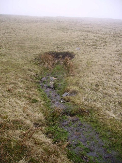
English: Source of the River Lune One of the three springs under Green Bell which forms Dale Gill and the River Lune. This spring appears to be the one drawn by Wainwright in his Howgill Fells book and suggested as the source of the mighty Lune. Wainwright pokes fun at the citizens of Lancaster for not making this spot a place of pilgrimage. Happily it is not a popular spot and remains wild and remote. Two citizens of Lancaster did worship at the spring today. Luck to Loyne! |
| Date | |
| Source | From geograph.org.uk |
| Author | Michael Graham |
| Attribution (required by the license) | Michael Graham / Source of the River Lune / |
| Camera location | | View this and other nearby images on: OpenStreetMap |
|---|
_heading:270.00&language=en)
| Object location | | View this and other nearby images on: OpenStreetMap |
|---|
_heading:270.00&language=en)
Licensing

|
This image was taken from the Geograph project collection. See this photograph's page on the Geograph website for the photographer's contact details. The copyright on this image is owned by Michael Graham and is licensed for reuse under the Creative Commons Attribution-ShareAlike 2.0 license.
|
This file is licensed under the Creative Commons Attribution-Share Alike 2.0 Generic license.
Attribution: Michael Graham
- You are free:
- to share – to copy, distribute and transmit the work
- to remix – to adapt the work
- Under the following conditions:
- attribution – You must give appropriate credit, provide a link to the license, and indicate if changes were made. You may do so in any reasonable manner, but not in any way that suggests the licensor endorses you or your use.
- share alike – If you remix, transform, or build upon the material, you must distribute your contributions under the same or compatible license as the original.
File history
Click on a date/time to view the file as it appeared at that time.
| Date/Time | Thumbnail | Dimensions | User | Comment | |
|---|---|---|---|---|---|
| current | 05:43, 19 February 2011 | | 480 × 640 (100 KB) | GeographBot | == {{int:filedesc}} == {{Information |description={{en|1=Source of the River Lune One of the three springs under Green Bell which forms Dale Gill and the River Lune. This spring appears to be the one drawn by Wainwright in his Howgill Fells book and sugge |
File usage
The following pages on the English Wikipedia use this file (pages on other projects are not listed):