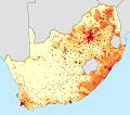
File:South Africa 2011 population density map (hex cells).svg
Appearance

Size of this PNG preview of this SVG file: 681 × 600 pixels. Other resolutions: 272 × 240 pixels | 545 × 480 pixels | 872 × 768 pixels | 1,162 × 1,024 pixels | 2,325 × 2,048 pixels | 807 × 711 pixels.
Original file (SVG file, nominally 807 × 711 pixels, file size: 1.41 MB)
File history
Click on a date/time to view the file as it appeared at that time.
| Date/Time | Thumbnail | Dimensions | User | Comment | |
|---|---|---|---|---|---|
| current | 15:43, 10 March 2021 |  | 807 × 711 (1.41 MB) | Htonl | == {{int:filedesc}} == {{Information |Description={{en|1=Population density map of South Africa, based on the 2011 census, using data aggregated to regular 50km<sup>2</sup> hexagonal cells. {{legend|#ffffcc|<1 inhabitant/km²}} {{legend|#ffeda0|1–3 inhabitants/km²}} {{legend|#fed976|3–10 inhabitants/km²}} {{legend|#feb24c|10–30 inhabitants/km²}} {{legend|#fd8d3c|30–100 inhabitants/km²}} {{legend|#fc4e2a|100–300 inhabitants/km²}} {{legend|#e31a1c|300–1000 inhabitants/km²}} {{legend|#bc0026|1... |
File usage
The following 2 pages use this file:
Global file usage
The following other wikis use this file:
- Usage on chy.wikipedia.org
- Usage on eu.wikipedia.org
- Usage on he.wikivoyage.org
- Usage on nso.wikipedia.org
- Usage on tum.wikipedia.org


