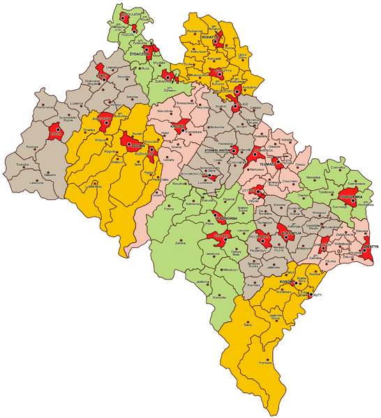
File:Stanisławów Voivodeship Administrative Map 1938.png
Appearance

Size of this preview: 546 × 600 pixels. Other resolutions: 218 × 240 pixels | 437 × 480 pixels | 699 × 768 pixels | 932 × 1,024 pixels | 2,211 × 2,429 pixels.
Original file (2,211 × 2,429 pixels, file size: 1.16 MB, MIME type: image/png)
File history
Click on a date/time to view the file as it appeared at that time.
| Date/Time | Thumbnail | Dimensions | User | Comment | |
|---|---|---|---|---|---|
| current | 21:46, 7 January 2010 |  | 2,211 × 2,429 (1.16 MB) | Qqerim | Added name "Bohorodczany" |
| 20:41, 7 January 2010 |  | 2,211 × 2,429 (1.15 MB) | Qqerim | Added arrow to the exclave of gmina Starunia | |
| 19:08, 7 January 2010 |  | 2,211 × 2,429 (1.15 MB) | Qqerim | == {{int:filedesc}} == {{Information |Description=Polska: Mapa administracyjna województwa stanisławowskiego, stan na rok 1938 (Administrative map of Stanisławów Voivodeship as of 1938) |Source={{own}} |Date=2010-01-07 |Author= Qqerim |
File usage
The following page uses this file:
Global file usage
The following other wikis use this file:
- Usage on be-tarask.wikipedia.org
- Usage on de.wikipedia.org
- Usage on fr.wikipedia.org
- Usage on it.wikipedia.org
- Usage on lt.wikipedia.org
- Usage on nl.wikipedia.org
- Usage on pl.wikipedia.org
- Usage on ru.wikipedia.org
- Usage on uk.wikipedia.org
- Usage on vi.wikipedia.org
- Usage on zh.wikipedia.org

