
File:Tenmile Creek in Coos County, Oregon.jpg

Size of this preview: 800 × 531 pixels. Other resolutions: 320 × 213 pixels | 640 × 425 pixels | 1,024 × 680 pixels | 1,280 × 850 pixels | 2,560 × 1,700 pixels | 4,288 × 2,848 pixels.
Original file (4,288 × 2,848 pixels, file size: 9.57 MB, MIME type: image/jpeg)
| This is a file from the Wikimedia Commons. Information from its description page there is shown below. Commons is a freely licensed media file repository. You can help. |
Summary
| Description |
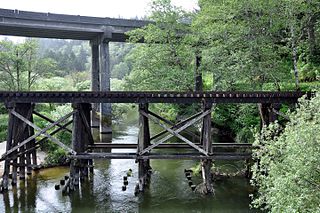
English: Tenmile Creek passes under a bridge carrying U.S. Route 101 and then a railway trestle. The creek, the outlet for nearby Tenmile Lake, continues west through sand dunes to the Pacific Ocean. The view is looking upstream from a third bridge that carries Spinreel Road (Wildwood Drive) over the creek. |
| Date | |
| Source | Own work |
| Author | Finetooth |
Licensing
I, the copyright holder of this work, hereby publish it under the following licenses:
This file is licensed under the Creative Commons Attribution-Share Alike 3.0 Unported license.
- You are free:
- to share – to copy, distribute and transmit the work
- to remix – to adapt the work
- Under the following conditions:
- attribution – You must give appropriate credit, provide a link to the license, and indicate if changes were made. You may do so in any reasonable manner, but not in any way that suggests the licensor endorses you or your use.
- share alike – If you remix, transform, or build upon the material, you must distribute your contributions under the same or compatible license as the original.

|
Permission is granted to copy, distribute and/or modify this document under the terms of the GNU Free Documentation License, Version 1.2 or any later version published by the Free Software Foundation; with no Invariant Sections, no Front-Cover Texts, and no Back-Cover Texts. A copy of the license is included in the section entitled GNU Free Documentation License. |
You may select the license of your choice.
File history
Click on a date/time to view the file as it appeared at that time.
| Date/Time | Thumbnail | Dimensions | User | Comment | |
|---|---|---|---|---|---|
| current | 02:45, 10 May 2016 | | 4,288 × 2,848 (9.57 MB) | Finetooth | {{Information |Description ={{en|1=Tenmile Creek passes under a bridge carrying U.S. Route 101 and then a railway bridge on its short journey from Tenmile Lake to the Pacific Ocean.}} |Source ={{ow... |
File usage
The following pages on the English Wikipedia use this file (pages on other projects are not listed):
Global file usage
The following other wikis use this file:
- Usage on www.wikidata.org