
File:The sealed entrance to Scoveston Fort - geograph.org.uk - 1431588.jpg
The_sealed_entrance_to_Scoveston_Fort_-_geograph.org.uk_-_1431588.jpg (640 × 480 pixels, file size: 122 KB, MIME type: image/jpeg)
| This is a file from the Wikimedia Commons. Information from its description page there is shown below. Commons is a freely licensed media file repository. You can help. |
Summary
| Description |
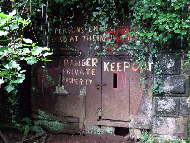
English: The sealed entrance to Scoveston Fort The extraordinary and massive structure that is Scoveston Fort is now privately owned and accessible to only the most determined, given that 60 years of brambles, nettles and prickly thicket have created an all-but impenetrable natural defensive system since it was last in use. However certain individuals have, with or without permission, photographed the interior, and pictures are available on the Web, for example http://www.palmerstonforts.org.uk/gall/Scoveston.php
The fort was built in the 1860s, one of "Palmerston's follies", so-called because a Royal Commission during his government reported a need to strengthen Britain's defences against the perceived might of the French navy (and it was not far away at Fishguard that the last invasion of British soil took place in 1797). Scoveston was one of a chain of 6 forts planned to defend the important naval dockyards and shipping lanes of Milford Haven, Neyland and Pembroke Dock. Most of the plan was scrapped except for this one, the only landward fortification. It was constructed between 1861-68 under the direction of Lieutenant Gordon of the Royal Engineers (later 'of Khartoum' fame) at the cost of £45, 462. The fort is hexagonal in shape, 130 in diameter, with bastions at the angles, a rampart on which 32 guns were to be mounted, and surrounded by a ditch 36 feet deep/wide. The outside edge of the ditch was cut out of the bedrock and the inside wall was made of smooth masonry so the whole thing would have been very hard to scale. Underground was an artillery magazine for storing ammunition. Although a garrison of 128 men was intended it was never installed and by the turn of the C19 Scoveston appears to have been surplus to requirement. However it was brought into use during WWI when it served as a temporary garrison for a battalion of the Welsh regiment preparing for war, and later as a barracks for a non-combatant labour corps of Russian nationals, called up and deployed to maintain coastal defences rather than to be trained as (possibly mutinous) front-line troops. In 1932 the disused fort was sold off to a local farmer for £1400 but during WWII it was requisitioned to serve as an anti-aircraft battery and then as an ammunition store in the build-up to D-Day. Local people apparently used it as an unofficial air-raid shelter, the docks being a major enemy target. Since then the fort has sunk, almost literally, into the landscape and is hardly visible from the ground. Aerial photographs reveal its size and surprising state of preservation. See http://www.coflein.gov.uk/en/site/268149/images/SCOVESTON+FORT/ |
| Date | |
| Source | From geograph.org.uk |
| Author | ceridwen |
| Attribution (required by the license) | ceridwen / The sealed entrance to Scoveston Fort / |
| Camera location | | View this and other nearby images on: OpenStreetMap |
|---|
_heading:337.00&language=en)
| Object location | | View this and other nearby images on: OpenStreetMap |
|---|
_heading:337.00&language=en)
Licensing

|
This image was taken from the Geograph project collection. See this photograph's page on the Geograph website for the photographer's contact details. The copyright on this image is owned by ceridwen and is licensed for reuse under the Creative Commons Attribution-ShareAlike 2.0 license.
|
- You are free:
- to share – to copy, distribute and transmit the work
- to remix – to adapt the work
- Under the following conditions:
- attribution – You must give appropriate credit, provide a link to the license, and indicate if changes were made. You may do so in any reasonable manner, but not in any way that suggests the licensor endorses you or your use.
- share alike – If you remix, transform, or build upon the material, you must distribute your contributions under the same or compatible license as the original.
File history
Click on a date/time to view the file as it appeared at that time.
| Date/Time | Thumbnail | Dimensions | User | Comment | |
|---|---|---|---|---|---|
| current | 00:09, 2 March 2011 | | 640 × 480 (122 KB) | GeographBot | == {{int:filedesc}} == {{Information |description={{en|1=The sealed entrance to Scoveston Fort The extraordinary and massive structure that is Scoveston Fort is now privately owned and accessible to only the most determined, given that 60 years of bramble |
File usage
Global file usage
The following other wikis use this file:
- Usage on cy.wikipedia.org
- Usage on www.wikidata.org