
File:Utm-zones.jpg

Original file (2,048 × 1,024 pixels, file size: 821 KB, MIME type: image/jpeg)
| This is a file from the Wikimedia Commons. Information from its description page there is shown below. Commons is a freely licensed media file repository. You can help. |
Summary
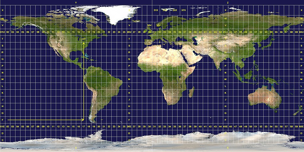
Longitude zones are six degrees wide. They are numbered from 01 at 180° west, increasing towards the east until 60 at 180° east.
Latitude zones are 8° high. They are lettered from C to X, omitting the letters "I" and "O", beginning at 80° south. The letters A, B, Y and Z are used in the polar regions by the Universal Polar Stereographic grid system.
A grid reference is read "right, up", as indicated by the arrows. A reference is always written with the longitude zone first. In this example, "17T".
Exceptions to the system are apparent. The west coast of Norway is given a wider zone 32V, taking some space from the zone 31V that covers open water. The zones around Svalbard are also widened, effectively deleting some longitude zones at this latitude. Finally, the entire latitude zone "X" is extended an extra 4°, topping off at 84° north.Licensing
This work is in the public domain in the United States because it is a work prepared by an officer or employee of the United States Government as part of that person’s official duties under the terms of Title 17, Chapter 1, Section 105 of the US Code.
Note: This only applies to original works of the Federal Government and not to the work of any individual U.S. state, territory, commonwealth, county, municipality, or any other subdivision. This template also does not apply to postage stamp designs published by the United States Postal Service since 1978. (See § 313.6(C)(1) of Compendium of U.S. Copyright Office Practices). It also does not apply to certain US coins; see The US Mint Terms of Use.
|
 | |
| This file has been identified as being free of known restrictions under copyright law, including all related and neighboring rights. | ||
This image was constructed from a public domain Visible Earth product of the Earth Observatory office of the United States government space agency NASA. It is based on a cylindrical equi-distant projection, and was marked up by custom software created specifically for the Wikipedia.
| This file is licensed under the Creative Commons Attribution-Share Alike 3.0 Unported license. Subject to disclaimers. | ||
| ||
| This licensing tag was added to this file as part of the GFDL licensing update. |

|
Permission is granted to copy, distribute and/or modify this document under the terms of the GNU Free Documentation License, Version 1.2 or any later version published by the Free Software Foundation; with no Invariant Sections, no Front-Cover Texts, and no Back-Cover Texts. A copy of the license is included in the section entitled GNU Free Documentation License. Subject to disclaimers. |
File history
Click on a date/time to view the file as it appeared at that time.
| Date/Time | Thumbnail | Dimensions | User | Comment | |
|---|---|---|---|---|---|
| current | 11:08, 26 January 2007 | | 2,048 × 1,024 (821 KB) | Jan Krymmel~commonswiki | The longitude and latitude zones in the Universal Transverse Mercator system. Longitude zones are six degrees wide. They are numbered from 01 at 180° west, increasing towards the east until 60 at 180° east. Latitude zones are 8° high. They are le |
File usage
Global file usage
The following other wikis use this file:
- Usage on ar.wikipedia.org
- Usage on ast.wikipedia.org
- Usage on ca.wikipedia.org
- Usage on cs.wikipedia.org
- Usage on da.wikipedia.org
- Usage on de.wikipedia.org
- Usage on es.wikipedia.org
- Usage on et.wikipedia.org
- Usage on eu.wikipedia.org
- Usage on fa.wikipedia.org
- Usage on he.wikipedia.org
- Usage on hu.wikipedia.org
- Usage on ilo.wikipedia.org
- Usage on ko.wikipedia.org
- Usage on mk.wikipedia.org
- Usage on nl.wikipedia.org
- Usage on no.wikipedia.org
- Usage on pl.wikipedia.org
- Usage on pt.wikipedia.org
- Usage on sv.wikipedia.org
- Usage on ta.wikipedia.org
- Usage on th.wikipedia.org
- Usage on uk.wikipedia.org
- Usage on zh.wikipedia.org