
File:WW2-Holocaust-Europe-2007Borders DE.png

Size of this preview: 721 × 600 pixels. Other resolutions: 289 × 240 pixels | 577 × 480 pixels | 923 × 768 pixels | 1,231 × 1,024 pixels | 1,310 × 1,090 pixels.
Original file (1,310 × 1,090 pixels, file size: 572 KB, MIME type: image/png)
| This is a file from the Wikimedia Commons. Information from its description page there is shown below. Commons is a freely licensed media file repository. You can help. |
| Description |
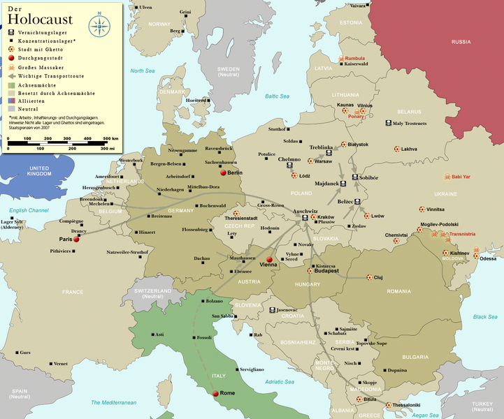
English: Map (with German legend) of the Holocaust in Europe during World War II, 1939-1945. This map shows all German Nazi extermination camps (or death camps), most major concentration camps, labor camps, prison camps, ghettos, major deportation routes and major massacre sites. Please note that a version with 1942 borders is available here: Image:WW2-Holocaust-Europe.png. Notes: 1. Extermination camps were dedicated death camps, but all camps and ghettos took a toll of many, many lives. 2. Concentration camps include labor camps, prison camps & transit camps. 3. Not all camps & ghettos are shown. 4. Borders are present borders (2007). |
| Date | (UTC) |
| Source | |
| Author |
|
| Other versions |
[]
|


.png)


.png)


| This is a retouched picture, which means that it has been digitally altered from its original version. Modifications: legend and title now german. The original can be viewed here: WW2-Holocaust-Europe-2007Borders.png:
|
I, the copyright holder of this work, hereby publish it under the following license:
This file is licensed under the Creative Commons Attribution 3.0 Unported license.
- You are free:
- to share – to copy, distribute and transmit the work
- to remix – to adapt the work
- Under the following conditions:
- attribution – You must give appropriate credit, provide a link to the license, and indicate if changes were made. You may do so in any reasonable manner, but not in any way that suggests the licensor endorses you or your use.

|
This historical map image could be re-created using vector graphics as an SVG file. This has several advantages; see Commons:Media for cleanup for more information. If an SVG form of this image is available, please upload it and afterwards replace this template with
{{vector version available|new image name}}.
It is recommended to name the SVG file “WW2-Holocaust-Europe-2007Borders DE.svg”—then the template Vector version available (or Vva) does not need the new image name parameter. |
Original upload log
This image is a derivative work of the following images:
- File:WW2-Holocaust-Europe-2007Borders.png licensed with Cc-by-3.0
- 2007-12-17T10:40:36Z Dna-webmaster 1310x1090 (785571 Bytes) == Summary == {{Information |Description=Map of the Holocaust in Europe during World War II, 1939-1945. This map shows all extermination camps (or ''death camps''), most major concentration camps, labor camps, prison camps,
Uploaded with derivativeFX
File history
Click on a date/time to view the file as it appeared at that time.
| Date/Time | Thumbnail | Dimensions | User | Comment | |
|---|---|---|---|---|---|
| current | 19:01, 2 November 2009 | | 1,310 × 1,090 (572 KB) | Flying Saucer | Vaivara correction |
| 20:59, 21 July 2009 |  | 1,310 × 1,090 (760 KB) | Emdee | legende: Allierte (typo!) -> Alliierten (plural) Große Transportroute -> Wichtige Transportroute | |
| 16:07, 21 July 2009 |  | 1,310 × 1,090 (760 KB) | Emdee | {{Information |Description={{en|Map (with german legend) of the Holocaust in Europe during World War II, 1939-1945. <br /> This map shows all extermination camps (or ''death camps''), most major concentration camps, labor camps, prison camps, ghettos, maj |
File usage
The following pages on the English Wikipedia use this file (pages on other projects are not listed):
Global file usage
The following other wikis use this file:
- Usage on ar.wikipedia.org
- Usage on be-tarask.wikipedia.org
- Usage on de.wikipedia.org
- Usage on et.wikipedia.org
- Usage on he.wikipedia.org
- Usage on pl.wikipedia.org
- Usage on ru.wikipedia.org
- Usage on zh.wikipedia.org