
File:West-Brabantse waterlinie.jpg
No higher resolution available.
West-Brabantse_waterlinie.jpg (677 × 311 pixels, file size: 135 KB, MIME type: image/jpeg)
| This is a file from the Wikimedia Commons. Information from its description page there is shown below. Commons is a freely licensed media file repository. You can help. |
Summary
| Description |
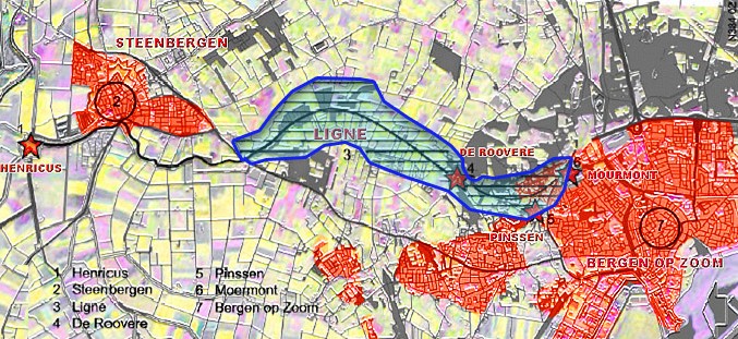
Nederlands: West-Brabantse waterlinie (later: Stelling West Noord-Brabant)
Voor de achtergrond gebruikt de satelietfoto: Bron NLR en ESA. Kleuropmaak Ed Stevenhagen
|
| Date | 28 July 2005 (original upload date) |
| Source | NLR/ESA |
| Author | The original uploader was Ed Stevenhagen at Dutch Wikipedia. |
Licensing
This file is licensed under the Creative Commons Attribution 2.5 Generic license.
- You are free:
- to share – to copy, distribute and transmit the work
- to remix – to adapt the work
- Under the following conditions:
- attribution – You must give appropriate credit, provide a link to the license, and indicate if changes were made. You may do so in any reasonable manner, but not in any way that suggests the licensor endorses you or your use.
Original upload log
The original description page was here. All following user names refer to nl.wikipedia.
- 2005-07-28 15:55 Ed Stevenhagen 724×325×8 (184610 bytes) Noor-Brabantse waterlinie Voor de achtergrond gebruikt de satelietfoto: Bron NLR en ESA. Kleuropmaak Ed Stevenhagen Oorspronkelijk kaart: zwartwit: Jhnijman (132259 bytes) met vermelding: "ik heb dit plaatje zelf gemaakt mbv Alterra Wageningen tbv een ar
File history
Click on a date/time to view the file as it appeared at that time.
| Date/Time | Thumbnail | Dimensions | User | Comment | |
|---|---|---|---|---|---|
| current | 18:40, 14 August 2009 | | 677 × 311 (135 KB) | Tekstman | (satisfying?) attempt to remove watermark |
| 23:30, 29 April 2008 |  | 724 × 325 (180 KB) | File Upload Bot (Magnus Manske) | {{BotMoveToCommons|nl.wikipedia}} {{Information |Description={{nl|Noor-Brabantse waterlinie Voor de achtergrond gebruikt de satelietfoto: Bron NLR en ESA. Kleuropmaak Ed Stevenhagen Oorspronkelijk kaart: zwartwit: Jhnijman (132259 bytes) met vermelding: |
File usage
The following pages on the English Wikipedia use this file (pages on other projects are not listed):
Global file usage
The following other wikis use this file:
- Usage on nl.wikipedia.org