Jump to content

File:Windstreak.jpg

Page contents not supported in other languages.
This is a file from the Wikimedia Commons
From Wikipedia, the free encyclopedia

Original file (1,020 × 1,016 pixels, file size: 324 KB, MIME type: image/jpeg)

  • Original Caption Released with Image:

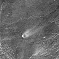
This comet-like tail, trending northeast from the volcanic structure, is a relatively radar-bright deposit. The volcano, with a base diameter of 5 kilometers (about 3 miles) is a local topographic high point that has slowed down northeast trending winds enough to cause deposition of this material. The streak is 35 kilometers (about 22 miles) long and 10 kilometers (about 6 miles) wide. The volcano is located at the western end of Parga Chasma at 9.4 degrees south latitude and 247.5 degrees east longitude.

This image or video was catalogued by Jet Propulsion Laboratory of the United States National Aeronautics and Space Administration (NASA) under Photo ID: PIA00243.

This tag does not indicate the copyright status of the attached work. A normal copyright tag is still required. See Commons:Licensing.
Other languages:


Public domain This file is in the public domain in the United States because it was solely created by NASA. NASA copyright policy states that "NASA material is not protected by copyright unless noted". (See Template:PD-USGov, NASA copyright policy page or JPL Image Use Policy.)
Warnings:

Captions

Add a one-line explanation of what this file represents

Items portrayed in this file

depicts

File history

Click on a date/time to view the file as it appeared at that time.

Date/TimeThumbnailDimensionsUserComment
current21:57, 1 September 2005Thumbnail for version as of 21:57, 1 September 20051,020 × 1,016 (324 KB)Bricktoplarger
20:09, 30 August 2005Thumbnail for version as of 20:09, 30 August 20051,001 × 998 (253 KB)Lotse*'''Original Caption Released with Image:''' This comet-like tail, trending northeast from the volcanic structure, is a relatively radar-bright deposit. The volcano, with a base diameter of 5 kilometers (about 3 miles) is a local topographic high point th

The following page uses this file:

Global file usage

The following other wikis use this file:

Metadata