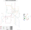
File:巴生谷综合运输系统路线图中文版 KwongTN.svg
Appearance

Size of this PNG preview of this SVG file: 424 × 600 pixels. Other resolutions: 170 × 240 pixels | 339 × 480 pixels | 543 × 768 pixels | 724 × 1,024 pixels | 1,448 × 2,048 pixels | 512 × 724 pixels.
Original file (SVG file, nominally 512 × 724 pixels, file size: 2.27 MB)
File history
Click on a date/time to view the file as it appeared at that time.
| Date/Time | Thumbnail | Dimensions | User | Comment | |
|---|---|---|---|---|---|
| current | 07:38, 24 April 2020 |  | 512 × 724 (2.27 MB) | Kwong Tung Nan | Removed extra assets |
| 07:23, 24 April 2020 |  | 512 × 503 (2.62 MB) | Kwong Tung Nan | Updated with respect to line renames | |
| 12:58, 30 April 2018 |  | 512 × 724 (3.25 MB) | Kwong Tung Nan | Technology Park科技园->保留车站; AEON Big Subang Jaya->AEON BiG | |
| 09:47, 28 April 2018 |  | 512 × 724 (3.25 MB) | Kwong Tung Nan | 移除了首都广场 | |
| 09:42, 28 April 2018 |  | 512 × 724 (3.26 MB) | Kwong Tung Nan | Edited skypark line stops and typo errors. | |
| 09:25, 7 April 2018 |  | 512 × 724 (3.26 MB) | Kwong Tung Nan | Edited to include: 1. The new colour scheme for Putrajaya Monorail Line. 2. Extension and stations for Skypark Line. 3. New landmarks. 4. [Chinese] Corrected translations. | |
| 06:46, 24 February 2018 |  | 512 × 724 (3.25 MB) | Kwong Tung Nan | Fixed naming schemes & edited future stations. | |
| 15:20, 23 February 2018 |  | 512 × 724 (3.24 MB) | Kwong Tung Nan | 新增了许多地标,更改了部分名字的错误 | |
| 03:59, 28 January 2018 |  | 512 × 724 (3.17 MB) | Kwong Tung Nan | 尝试解决 png 呈现问题 | |
| 03:53, 28 January 2018 |  | 512 × 724 (2.23 MB) | Kwong Tung Nan | 修改了粗心的错误,以及更改了一些地标的呈现方式 |
File usage
The following pages on the English Wikipedia use this file (pages on other projects are not listed):
Global file usage
The following other wikis use this file:

