
Fjærlandsfjorden
| Fjærlandsfjorden | |
|---|---|
 Fjærlandsfjorden Location in Sogn og Fjordane county | |
| Location | Sogn og Fjordane county, Norway |
| Coordinates | 61°24′15″N 6°45′06″E / 61.4042°N 6.7517°E |
| Primary outflows | Sognefjorden |
| Basin countries | Norway |
| Max. length | 25 kilometres (16 mi) |
| Max. width | 1.5 kilometres (0.93 mi) |
| Settlements | Balestrand, Fjærland |
Fjærlandsfjorden is a fjord in Sogn og Fjordane county, Norway. It is a fjord arm that branches off the main Sognefjorden to the north, running through the municipalities of Balestrand, Leikanger, and Sogndal. The 25-kilometre (16 mi) long fjord begins at the village of Fjærland in Sogndal, flowing to the south until it joins the Sognefjorden near the village of Balestrand. The Esefjorden and Vetlefjorden are two small fjord arms that branch off the Fjærdlandsfjorden. The fjord is about 1.5 kilometres (0.93 mi) wide, with steep mountains on both sides of the fjord. The head of the fjord is the only habitable area around the fjord. It is a flat river valley extending north of the fjord. The inner part of the fjord where the village of Fjærland is located is only accessible by boat or via long road tunnels through the surrounding mountains. The western end of the Frudal Tunnel sits very near the shore of the fjord.[1]
Media gallery
-
 Looking north towards Fjærland
 -
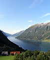
 View of the fjord
 -
 Another view of the fjord
 -
 Looking south
 -
 Looking north from atop a mountain
.jpg)


See also
References
- ^ Store norske leksikon. "Fjærlandsfjorden" (in Norwegian). Retrieved 2014-02-09.