
Fort Vijfhuizen

Fort Vijfhuizen is one of forty-two forts in the Defense Line of Amsterdam (Dutch: stelling van Amsterdam), a World Heritage Site. It is located in the town of Vijfhuizen on the ringvaart which surrounds the Haarlemmermeer polder. The main fort is currently maintained by a charitable foundation called Kunstfort Vijfhuizen which leases space for twelve artist studios and a restaurant.
The fort is situated on a hill surrounded by a moat and accessible during opening hours. It was built in 1889-1890 with sand taken from the excavations for a new sluice-gate complex in IJmuiden.[1] On 3 May 1943 an American Ventura bomber crashed into the moat.[1]
South of this fort, also along the ringvaart, is the first fore position of the fort, currently part of a golf course. A bit further south is yet another fore position at fort Cruquius, just south of the Cruquius Museum.
-
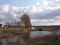 View of the geniedijk, looking southwest from fort Vijfhuizen.
 -
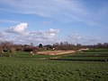 View of bunkers, representing fore position of fort Vijfhuizen.
 -
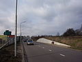 View of the road crossing the bunkers of fort Cruquius, the secondmost fore position of fort Vijfhuizen (seen from below the dike looking up towards the ringvaart. The trees are on the Heemstede side of the canal).


References
- ^ a b Fort bij Vijfhuizen on Stelling van Amsterdam website