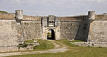
Fort de La Prée


Fort de La Prée, built in 1625, is located near the eastern end of the Île de Ré, in France.[1]
History
In 1625, the French officer Toiras led the Royalist troops when they captured Ré from the Huguenots under the command of admiral Duke of Soubise. After his victory, Toiras received the title of Count, and became Governor of Île de Ré. It was he who built Fort de La Prée. He also worked on the larger fortifications at Saint-Martin-de-Ré.

The Duke Buckingham ignored Fort de La Prée during his three-month siege of Saint-Martin-de-Ré in 1627. This neglect fatally weakened his position on the island. Toiras managed to land troops there and force the English to give up their siege and withdraw in defeat.[2]
Notes
46°10′51″N 1°17′19″W / 46.1808°N 1.2887°W
