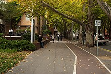
Frome Road

Frome Road (34°55′01″S 138°36′22″E / 34.917°S 138.606°E) is a connecting road in the South Australian capital city of Adelaide. It starts from North Terrace in the Adelaide city centre, running in a northerly direction past the University of South Australia, the old Royal Adelaide Hospital, the Institute of Medical and Veterinary Science and the University of Adelaide, and then through the Adelaide Parklands to the Adelaide Zoo where it turns northeasterly, crosses the River Torrens via Albert Bridge, and continues through the parklands to the intersection with Melbourne Street and Brougham Place in North Adelaide.[1]
It is one of the three roads connecting the city centre to North Adelaide, the others being King William Road and Montefiore Road.
Frome Road is the northern continuation of Frome Street, which runs through the Adelaide city centre from North Terrace to Carrington Street.
The road (and street) are named after Edward Charles Frome, a Surveyor General of South Australia.
References
- ^ 2003 Adelaide Street Directory, 41st Edition. UBD (A Division of Universal Press Pty Ltd). 2003. ISBN 0-7319-1441-4.
