
Gassel
Gassel | |
|---|---|
 Gassel in 1865 | |
| Coordinates: 51°44′25″N 5°46′49″E / 51.74028°N 5.78028°E | |
| Country | Netherlands |
| Province | North Brabant |
| Municipality | Grave |
| Area | |
| • Total | 6.68 km2 (2.58 sq mi) |
| Population (2007) | 1,170 |
Gassel is a village in the Dutch province of North Brabant. It is located in the municipality of Grave.
Gassel was a separate municipality since the year 1811 until 1942, when it was merged with Beers.[1] In the year 1994 the municipality Beers was divided between Cuijk and Grave, and so Gassel became incorporated into Grave.
History
Gassel is a relatively old village and its name was mentioned first in 1337. The origin of the name probably lies in the old Dutch word gestel which designates a height between two rivers. This height is now situated approximately 1 km south of river Maas and 1 km north of the small river Raam.
At the census during the French reign in 1795 the population counted to 308 inhabitants. About the year 1865 there lived 576 inhabitants, according to the so-called Kuiper map. In 1972 there were 900 and in 2007 already 1173 inhabitants.
-
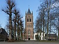 Gassel, church: de Sint Janskerk
 -
 Gassel, windmill


References
- ^ Ad van der Meer and Onno Boonstra, Repertorium van Nederlandse gemeenten, KNAW, 2011.
External links
- Template:Kuyper Map of the former municipality, around 1868.
- BHIC
- Smits-orgel
- V.V. Gassel
- Edos
- Hofkapel De Notenbalkers
- Stichting Dorpsraad Gassel
This North Brabant location article is a stub. You can help Wikipedia by expanding it. |