
Gennargentu
This article needs additional citations for verification. (December 2009) |
| Gennargentu | |
|---|---|
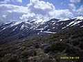
 View of Gennargentu and Gusana Lake in spring | |
| Highest point | |
| Peak | Punta La Marmora |
| Elevation | 1,834 m (6,017 ft) |
| Geography | |
| Country | Italy |
| Region | Sardinia |
Gennargentu (IPA: [dʒennarˈdʒɛntu]) is a large massif in central-southern Sardinia, Italy, encompassing the provinces of Nuoro and Ogliastra. It includes the highest peaks on the island, such as Punta La Marmora (1,834 m), Monte Spada (1,595 m), Punta Erba Irdes (1,676 m), Bruncu Spina (1,829 m) and Punta Paulinu (1,792 m).
The range forms part of the Gennargentu National Park. Geologically, its rocks are amongst the oldest in Europe, and are therefore smooth shaped: rock types include schist, limestone and granite.
Toponymy
The etymology of the name Gennargentu isn't attested, it could mean Door of Silver (Sardinian language: jenna de argentu), Door of the Winds (Sardinian language: Jenna de bentu) or Door of absinthium.
Ski Resorts
The mountains are home to the only ski resorts on the island: on Monte Spada, Bruncu Spina, Separadorgiu and S'Arena.[1][2]
Gallery
-
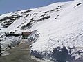
 near ski tracks
 -
 "rifugio Broncu Spina"
 -
 Genna Orisa and Bruncu Spina II - near Punta La Marmora
 -
 "Sa Panargia"
 -
 Ski resort in Bruncu Spina
 -
 Ski tracks on Gennargentu
 -
 Winter view on Gennargentu
 -
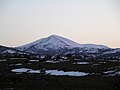 Monte Spada
 -
 Monte Fumai
 -
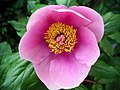 Paeonia of Gennargentu
 -
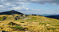
 Arcu Atillai in summer
 -
 Bruncu Spina - 1829 meters on sea level. - Sardinia
 -
 Monte Spada and the town of Fonni


See also
References
This Sardinia location article is a stub. You can help Wikipedia by expanding it. |