
Gmina Rudnik, Silesian Voivodeship
Gmina Rudnik
Rudnik Commune | |
|---|---|
,_silnice.jpg) Road in Sławienko | |
_COA.svg) Coat of arms | |
| Coordinates (Rudnik): 50°7′42″N 18°11′0″E / 50.12833°N 18.18333°E | |
| Country | |
| Voivodeship | Silesian |
| County | Racibórz |
| Seat | Rudnik |
| Area | |
| • Total | 73.94 km2 (28.55 sq mi) |
| Population (2006) | |
| • Total | 5,266 |
| • Density | 71/km2 (180/sq mi) |
| Website | http://www.gmina-rudnik.pl |
Gmina Rudnik is a rural gmina (administrative district) in Racibórz County, Silesian Voivodeship, in southern Poland. Its seat is the village of Rudnik, which lies approximately 7 kilometres (4 mi) north-west of Racibórz and 60 km (37 mi) west of the regional capital Katowice.
The gmina covers an area of 73.94 square kilometres (28.5 sq mi), and as of 2006 its total population is 5,266.
Villages
Gmina Rudnik contains the villages and settlements of Brzeźnica, Czerwięcice, Dolędzin, Gacki, Gamów, Grzegorzowice, Jastrzębie, Kolonia Strzybnik, Lasaki, Ligota Książęca, Łubowice, Modzurów, Ponięcice, Rudnik, Sławienko, Sławików, Strzybniczek, Strzybnik and Szonowice.
Neighbouring gminas
Gmina Rudnik is bordered by the town of Racibórz and by the gminas of Baborów, Cisek, Kuźnia Raciborska, Nędza, Pietrowice Wielkie and Polska Cerekiew.
Gallery
-
 Memorial in Łubowice
 -
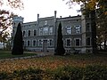 Palace in Modzurów
 -
 Road in Ligota Książęca


,_ulice.jpg)
References
| Seat | | |
|---|---|---|
| Other villages | ||
| Urban gminas |
|  |
|---|---|---|
| Urban-rural gminas | ||
| Rural gminas | ||