
Golur Bridge
12°07′02″N 76°42′19″E / 12.117114°N 76.705253°E

Golur Bridge is a small village in Mysore district of Karnataka state in India.
Location
Golur Bridge village is located two kilometer east of Nanjangud town.[1]
Administration
Golur Bridge is part of H.D.Kote Taluk in Mysore district of Karnataka state in India.[2]
Demographics
Golur Bridge village has a population of 3,402 people. [3]
Transportation
Golur junction deviates the road from Nanjangud to the T.Narasipur road on the left and the Chamarajanagar road on the right.
Image gallery
-
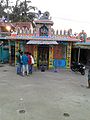 Village temple
 -
 Prayer hall
 -
 Primary School
 -
 Golur Junction


See also
References
- ^ https://www.google.co.in/maps/dir/12.1170717,76.7023561/Golur,+Karnataka+571129/@12.1152042,76.7020996,17z/data=!3m1!4b1!4m8!4m7!1m0!1m5!1m1!1s0x3baf426157812cbb:0xb7726e52c86785ec!2m2!1d76.7062336!2d12.113343
- ^ http://www.onefivenine.com/india/villages/Mysore/Heggadadevankote/Golur
- ^ http://www.census2011.co.in/data/village/619244-golur-karnataka.html