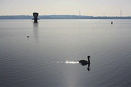
Grafham Water
| Grafham Water | |
|---|---|
 Grafham Water | |
| Location | Cambridgeshire |
| Coordinates | 52°17′53″N 0°18′54″W / 52.29810°N 0.31504°W |
| Lake type | reservoir |
| Managing agency | Anglian Water |
| Built | 1965 |
| Max. length | 4.3 km (2.7 mi) |
| Max. width | 2.35 km (1.46 mi) |
| Surface area | 6.28 km2 (1,550 acres) |
| Water volume | 57.8×10⁶ m3 (2.04×10⁹ cu ft) |
Grafham Water is an 806.3-hectare (1,992-acre) biological Site of Special Scientific Interest (SSSI) southwest of Huntingdon in Cambridgeshire. It was designated an SSSI in 1986.[1][2] It is a reservoir with a circumference of about 16 km (10 mi), and is the eighth largest reservoir in England by volume and the third largest by area at 6.27 km2 (1,550 acres). An area of 114 ha (280 acres) at the western end is a nature reserve managed by the Wildlife Trust for Bedfordshire, Cambridgeshire and Northamptonshire.[3]
The lake was created by building an earth and concrete dam, constructed by W. & C. French in 1965,[4] and water is extracted and processed at an adjacent Anglian Water treatment plant before being piped away as drinking water.
Water is obtained by pumping water from the River Great Ouse nearby. There are two pumping stations associated with the reservoir. One is located just behind the dam, the other at Offord Cluny alongside the River Great Ouse. At times of high potential flood risk, Grafham Water treatment works can increase the amount of water it takes up to maximum capacity to help reduce the risk of flooding along the river.
The reservoir was immediately colonised by wildlife and a nature reserve was created at the western side of the reservoir.[3] The nature reserve contains semi-natural ancient (at least 400 years old) woodlands and more recent plantation woodlands, grasslands and wetland habitats such as reedbeds, willow and open water.[5] As of January 2011, it was the only site in England, and the first in the UK, to harbour the invasive killer shrimp (Dikerogammarus villosus).[6][7] The reservoir has nationally important numbers of wintering great crested grebes, tufted ducks and coots, and of moulting mute swans in late summer. A pond has a population of the nationally uncommon warty newt.[8]
Grafham Water is popular for a range of leisure activities including sailing, fly fishing and cycling.
-
The Grafham Water reservoir from the air
-
Ducklings at Grafham Water
-
The Grafham Water dam
See also
References
- ^ "Designated Sites View: Grafham Water". Sites of Special Scientific Interest. Natural England. Retrieved 7 December 2016.
- ^ "Map of Grafham Water". Sites of Special Scientific Interest. Natural England. Retrieved 7 December 2016.
- ^ a b "Grafham Water". Wildlife Trust for Bedfordshire, Cambridgeshire and Northamptonshire. Retrieved 7 December 2016.
- ^ "Buckden: A Huntingdonshire Village". p. 154. Retrieved 14 September 2015.
- ^ Nick Bingham; Andrew Blowers; Christopher Belshaw (2003). Contested Environments. John Wiley and Sons. ISBN 0-470-85000-0.
- ^ "Alien 'killer' shrimp found in UK". BBC News. September 9, 2010. Retrieved September 9, 2010.
- ^ "Invasive shrimp found at Grafham Water". Environment Agency. September 9, 2010. Archived from the original on September 14, 2010. Retrieved May 22, 2011.
{{cite news}}: Unknown parameter|deadurl=ignored (|url-status=suggested) (help) - ^ "Grafham Water citation" (PDF). Sites of Special Scientific Interest. Natural England. Retrieved 7 December 2016.
External links
![]() Media related to Grafham Water at Wikimedia Commons
Media related to Grafham Water at Wikimedia Commons


