Great Falls (Housatonic River)
Appearance
| Great Falls | |
|---|---|
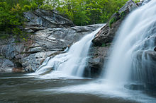
 Great Falls, springtime of 2013 | |
 | |
| Location | Falls Village, Canaan, Connecticut |
| Total height | 50 feet / 15 metres |
| Total width | 112 feet / 34 metres |
| Watercourse | Housatonic River |
Great Falls is a waterfall formed along the Housatonic River at Falls Village in the town of Canaan amidst Connecticut's Litchfield Hills. Great Falls is the highest volume waterfall in the state,[1] though a great deal of its potential water volume is diverted immediately upstream during most of the year for hydro-electric power generation.[2]
References
- ^ "Great Falls: Canaan (Falls Village), CT - Statistics". Connecticut Waterfalls. David A. Ellis. Retrieved 3 November 2015.
- ^ Tyburski, Betty. "Early Historical Highlight of the Town of Canaan". Town of Canaan. Town of Canaan. Retrieved 3 November 2015.
41°57′45″N 73°22′20″W / 41.9625°N 73.3722°W
