Jump to content

Höllental (Wetterstein)

Coordinates: 47°26′28″N 11°02′02″E / 47.441037°N 11.033885°E / 47.441037; 11.033885
From Wikipedia, the free encyclopedia

This is an old revision of this page, as edited by Ser Amantio di Nicolao (talk | contribs) at 20:22, 22 February 2016 (Cat-a-lot: Moving from Category:Gorges of Germany to Category:Canyons and gorges of Germany). The present address (URL) is a permanent link to this revision, which may differ significantly from the current revision.

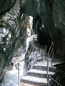
The path passes through a narrow gorge at one point.

The Höllental, English translation "Hell Valley" or "Valley of Hell" is one of the routes on the German side leading up the Zugspitze on the German-Austrian border in the northern Alps. It is located in the district of Garmisch-Partenkirchen.

See also

47°26′28″N 11°02′02″E / 47.441037°N 11.033885°E / 47.441037; 11.033885