Hoek van Holland Strand metro station
Hoek van Holland Strand | ||||||||||||||||
|---|---|---|---|---|---|---|---|---|---|---|---|---|---|---|---|---|
 | ||||||||||||||||
| General information | ||||||||||||||||
| Location | Hoek van Holland Netherlands | |||||||||||||||
| Coordinates | 51°58′58″N 4°7′10″E / 51.98278°N 4.11944°E | |||||||||||||||
| Operated by | Rotterdam Metro | |||||||||||||||
| Line(s) | Schiedam–Hoek van Holland railway | |||||||||||||||
| Platforms | 2 | |||||||||||||||
| Other information | ||||||||||||||||
| Station code | Hlds | |||||||||||||||
| History | ||||||||||||||||
| Opened | 1893 | |||||||||||||||
| Services | ||||||||||||||||
| ||||||||||||||||
| ||||||||||||||||
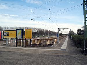
Hoek van Holland Strand metro station is a metro station in Hoek van Holland, the Netherlands. It consists of two tracks with side platforms, and is the terminus of the Schiedam–Hoek van Holland railway to Rotterdam. It was opened on 1 June 1893. Its name is derived from the nearby North Sea beach, strand being Dutch for “beach”.
The Nederlandse Spoorwegen stopped operating the line, including Hoek van Holland Strand railway station, on 1 April 2017. The line has been transferred to Rotterdam Metro. After reconstruction of the rail infrastructure and the facilities the opening of the metro line is expected in Spring 2021.[1]
Train services
Currently closed for reconstruction, the station has no regular service.
References
- ^ "Metro pas in 2021 door naar Hoek van Holland Strand" (in Dutch). Treinreiziger.nl. Retrieved 8 September 2018.


