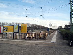
Hoek van Holland Strand metro station
Hoek van Holland Strand | |||||||||||
|---|---|---|---|---|---|---|---|---|---|---|---|
 | |||||||||||
| General information | |||||||||||
| Location | Hoek van Holland Netherlands | ||||||||||
| Coordinates | 51°58′58″N 4°7′10″E / 51.98278°N 4.11944°E | ||||||||||
| Operated by | Nederlandse Spoorwegen | ||||||||||
| Line(s) | Schiedam–Hoek van Holland railway | ||||||||||
| Platforms | 2 | ||||||||||
| Other information | |||||||||||
| Station code | Hlds | ||||||||||
| History | |||||||||||
| Opened | 1893 | ||||||||||
| Services | |||||||||||
| |||||||||||
Hoek van Holland Strand railway station is in the Netherlands. It consists of two tracks with side platforms, and is the terminus of the Schiedam–Hoek van Holland railway to Rotterdam. It was opened on 1 June 1893. Its name is derived from the nearby North Sea beach, strand being Dutch for “beach”.

Train services
From April to October the twice-hourly trains on the branch terminate here between 0800 and 2100, terminating at Hoek van Holland Haven at other times. From November to March between 1100 and 1600 trains are twice-hourly to Hoek van Holland Haven, continuing hourly to Hoek van Holland Strand.
The following services call at Hoek van Holland Strand:
- 2x per hour local service (Sprinter) Hoek van Holland - Rotterdam
